


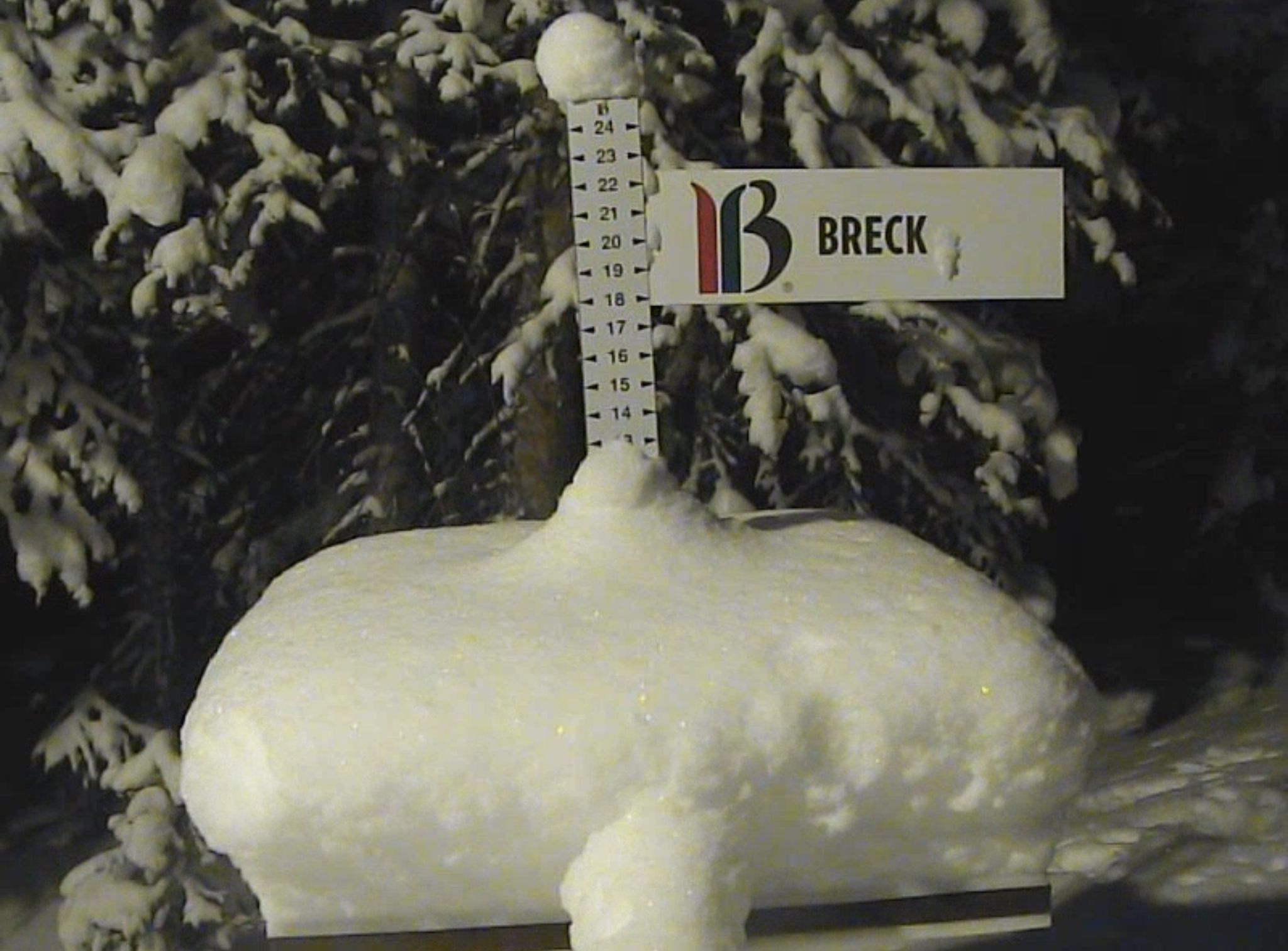
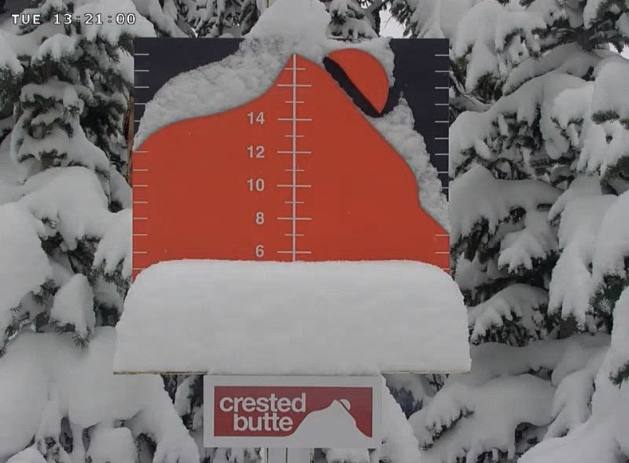
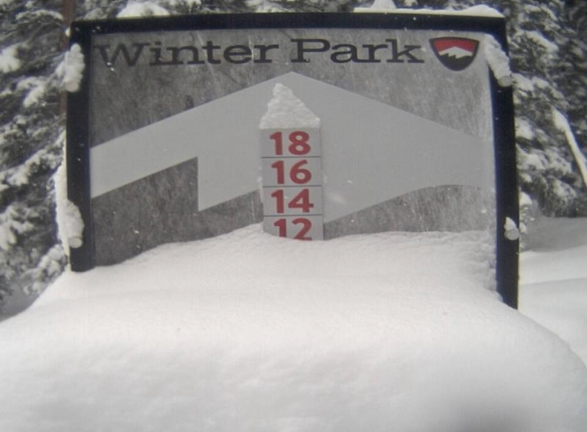
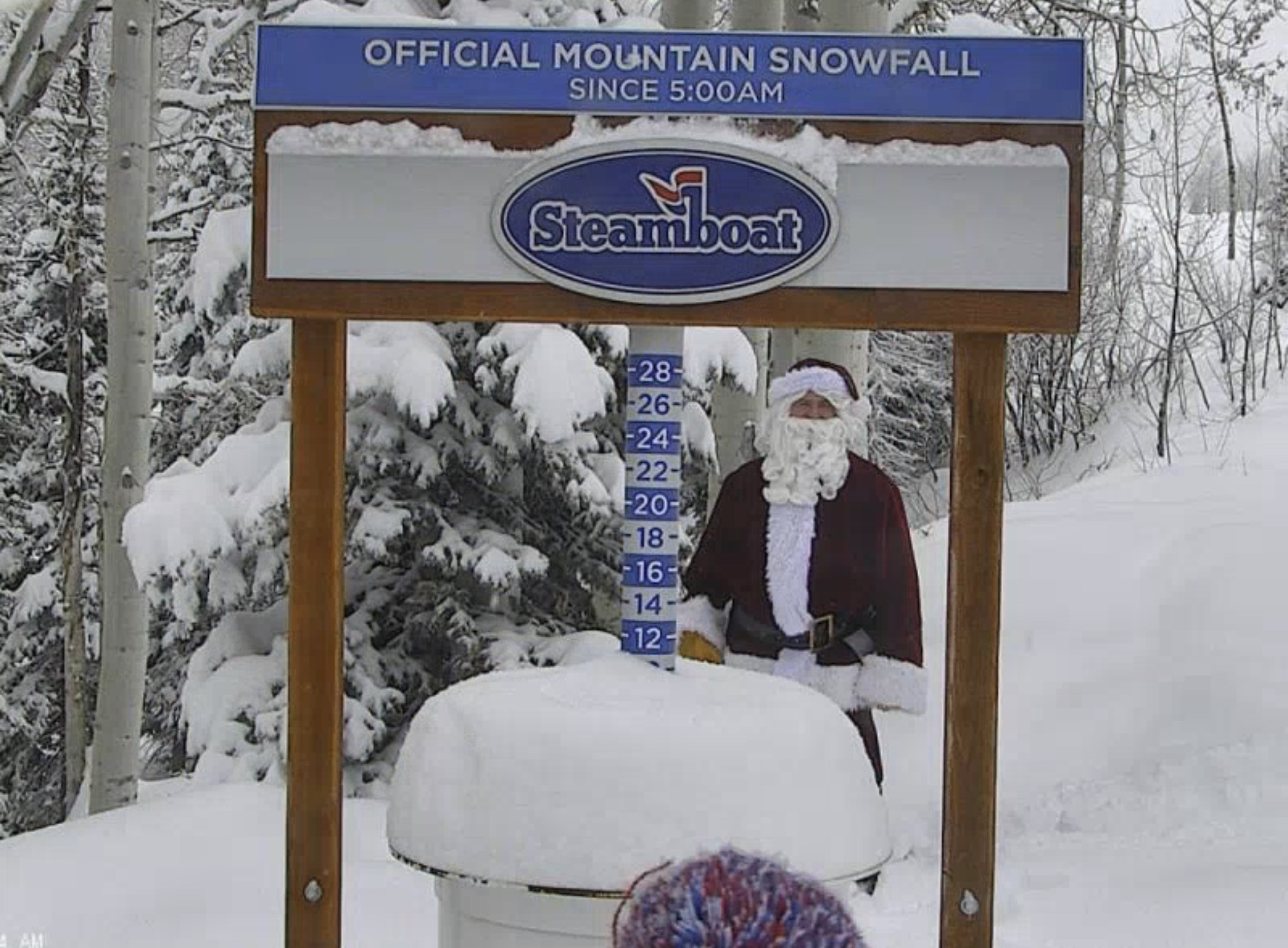
Daily Snow Stakes
 GFS Surface Chart

All Snow Version
Forecast Summary
The active pattern is just starting to crank back up after a little over a week and counting for Lake Tahoe. While other areas in the west have had a shorter time to wait. It’s hard to complain after the last couple of seasons of below average snowpack. Tomorrow we will look ahead to Presidents Day Weekend.
Let’s take a look at where we are with current snowpack. This is a chart from the National Snow and Ice Data Center.

We are on the upper end of the interquartile range. I had to look interquartile up, I always called it the mid-spread in back in the day, but interquartile sounds good, so I’m going with it. Let’s make it the “word of the day”–try to work it into conversation. “You know Bill, I was looking at the Chief’s offence vs Cincy’s defense, over the last 3 games they met, did you know the interquartile average favors KC”?
Sorry, back on track now. As the active pattern cranks back up, so should the needle on the chart. The MJO (Madden Jullian Oscillation) is beginning to move in the right direction for enhancing precipitation in mid-February. Even if the MJO doesn’t come through, there will still be good storms through February 26th, with the highest probability of strong storms between the 10-26th.
LR Prediction Forecast Chart
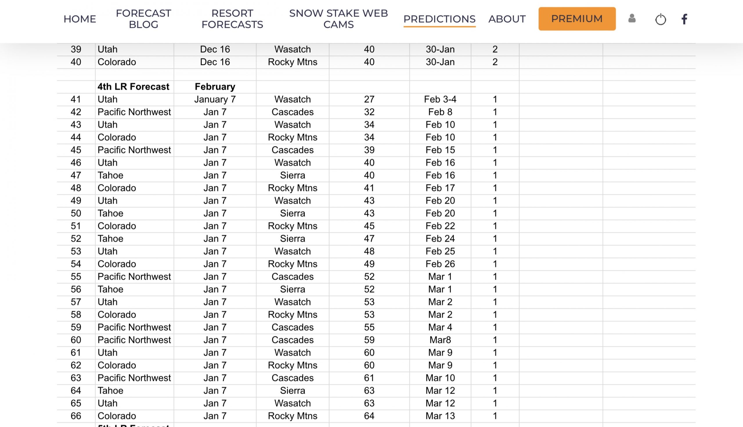
Storm 41 Overnight, storm 41 on your scorecard, hits the Pacific Northwest and slides southeast on a track that will clip northern Colorado. This system is one of the storms I was looking for when we were still uncertain of the cycle length. It is followed by a secondary wave that will dive deeper into Utah and Colorado that is storms 42 and 43.
Storm History
The last time these two waves came through we had primarily rain for the first wave in the PNW followed by snow for the second wave. Mt Hood was the winner with 6 snow and 2 inches of rain, Whistler 5, Crystel 4, and Mt Bachelor 5. In Utah, Alta had 2-day totals of 8, While in Colorado, a rare time where the state has outperformed Utah, with Breckenridge 14, Beaver Creek 13, Steamboat 11, Vail 9, Wolf Creek and Aspen 7. Also, a rare spotting of Santa before Christmas.

Forecast
Colorado

Today
The first wave moves in this morning for the northern resorts, 11 am for areas along the divide, 1 o’clock for central and 2-3 for the southern mountains, although I do not expect much, if any for the south. Temperatures will be in the low to mid-20’s. Winds will be strongest along the divide and northern mountains, getting lighter as you move south.
Wind (click to enlarge)


Northern resorts, Steamboat, Vail, Beaver Creek, and Winter Park will have moderate winds as the storm approaches. Expect 15 to 20 mph winds with gusts up to 30 mph. Centran and southern resorts are in a better position for winds. Generally, expect light to moderate winds.
For Loveland and Arapahoe Basin, we are looking at strong winds getting stronger during the day as the storm moves in. Expect 25-30 mph winds with up to 5o mph gusts.
Tomorrow
The winds are more reasonable for the northern ranges, between 10-15 mph with the exception of the divide, where we are still looking at moderate winds between 20-25 with 35 mph gusts. Temperatures in the mid 20’s.
 Next System Sunday
Utah

Snow throughout the day today with cold temperatures with the high around 20 at base. Strong winds between 25-30 mph with gusts around 40 mph. The heaviest precipitation will fall after the lifts close today, so expect a nice powder day tomorrow.
Tomorrow
Snow continues tomorrow morning until early afternoon. High temperatures around 15 degrees at base level with wind chills near zero. Moderate winds from 10-15 mph.

Next System Sunday
Pacific NW

Today
Snow showers today through early afternoon, with temperatures in the upper 20’s to around 30. Winds are froem the northwest and strong between 25-35 mph with 45 mph gusts.
Tomorrow
The second wave comes thru early tomorrow morning. It will be less windy, but the wind chills will make it feel like it’s in the low teens, so dress warm. Temperatures will begin the day in the mid 20’s and will be falling throughout the day, settling in the single digits by 6 pm.

Lake Tahoe (System for Sunday)

Tahoe gets back in on the action early Sunday morning, as storm 41 moves into the Tahoe basin. This will begin the active period again and will have storms rolling in about every 4-5 days with a pretty large storm expected for Presidents Day weekend (16th), and another good storm on the 20th.
Thank you for reading the blog, as always, if you have any questions, or need personalized info for trip forecasts, please email me at Mike@FutureSnow.co
Long-Range Forecast Predictions thru March
 Forecasted Areas
Pacific Northwest Cascade Mountains
Crystal Mountain, Mount Hood Meadows, Timberline, 49 Degrees North, Bachelor, Mt Baker,
Lake Tahoe Sierra Mountains
Heavenly, Palisades Tahoe, Kirkwood, Dodge Ridge, Donner Ski Ranch
Utah Wasatch Mountains
Alta, Park City, Deer Valley, Brighton, Snowbird, Brian Head
Colorado Rocky Mountains
Aspen, Aspen Highlands, Snowmass, Vail, Beaver Creek, Winter Park, Keystone, Arapahoe Basin, Breckenridge, Copper Mountain, Powderhorn, Ski Cooper, Telluride, Crested Butte, Silverton, Wolf Creek, Eldora, Loveland
–
