 Predictions Chart Update
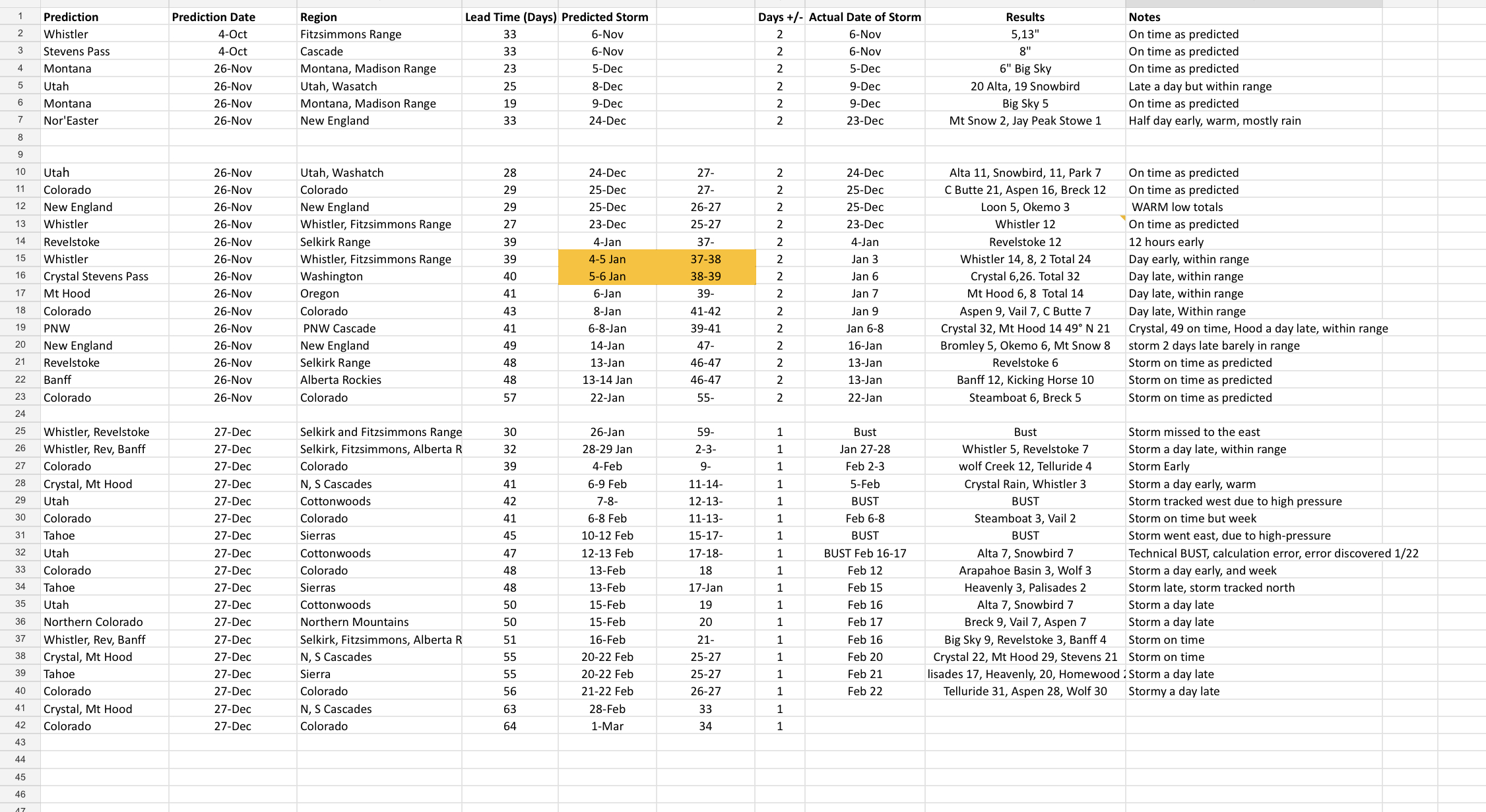
86.1 % Accurate, Average lead time of storms 38.5 days
We have to be transparent when it comes to our predictions, so we have updated our predictions chart and it is posted under this link. It is downloadable, so you can make sure we don’t cheat!
We shot out of the gate with a perfect record, hitting 20 out of 20. Then we hit a rough patch where we had 4 BUSTS in three weeks. The double barrel high pressure system wiped out our signature storm, the Trifecta. Although technically, we did get that storm right (Steamboat 3, Vail 2), I am counting that as a bust.
We did have a calculation error too. that storm (Utah Cottonwoods Feb 12-13) was entered incorrectly in our algorithm and was 4 days off. It should have read Feb 16-17. It was discovered within 22 days, but I will not change the spreadsheet and it will remain a bust.
After the rough patch, we got back on track and the strength of the Pattern intensified. We have hit our last 8 in a row and that looks to continue with our next prediction on track for the Cascades on Sunday/Monday.
You total that up and we are 31-36, or 86.1% accurate on our predicted storms, with an average lead time of 38.5 days. Lead times for the last set of predictions were 30-64 days out! Overall, I am pleased with our record and look forward to the rest of the season. Even when we got creamed with the ridge of high pressure and the high over Nevada, the storms were there, they were just pushed over the ridge and east of the Nevada high. I have full confidence that the rest of Cycle 3 will be similar to Cycle 1. Hopefully Cycle 4 will mirror Cycle 2 and be an exclamation point to the season in April.
Forecast
Northern Cascades 2-3 feet expected for higher ranges

Saturday Night
Snow returns tonight to the Pacific Northwest’s northern Cascades tonight. This is a small Atmospheric River (AR) event that will bring warm waters from the south Pacific. Freezing levels are in the 3500 range when the storm begins with strong winds from the southwest 15-25 mph.
Expect 4-8 inches for the higher resorts like Crystal Mountain. The southern Cascade resorts like Mt Hood Meadows and Timberline, I am expecting more rain and less snow with 2-4 expected. Below is an animation showing the flow from the south Pacific.
Sunday
Northern Cascades
Snow and wind with gusts around 30mph. Freezing levels around 4000 ft. Expect another 3-5 during the day with a nice dump of 6-12 overnight as the AR kicks into gear. The dumping continues Monday with another foot to a foot in a half of Cascade concrete.
Southern Cascades
Snow in the morning with rising snow levels and strong winds with gusts over 40 mph. The forecast for Mt Hood is tricky with this AR. Will it be warm enough that it will just be mainly rain Sunday, or a mix? Hard to call right now. I am thinking at least 2-4 more of snow with a mix during the daytime hours.
Next System arrives Thursday to the PNW
Spring Break Forecast for March
Spring break is right around the corner, so I thought I would break down, week by week, what will happen and more importantly, where the snow will be for the month of March.
March 1-5
March kicks off with a bang. In cycles 1 and 2 Utah had snow, so March 1-3 for Alta, Snowbird and the other cottonwood resorts.
Colorado had light snow, cycle 1 on the same days with heavy snow on day 27 (Mar 4). I expect the same in cycle 3, with the caveat, in cycle 2 it dumped, so a repeat like that would be a welcome surprise.
March 6-12
There is a split, during this week, in terms of pattern storms from the last 2 cycles. The one constant is Colorado. Colorado resorts received snow on days 33-35, which translates to March 9-11. Expect a good system for Vail, Steamboat, Aspen, Breckenridge and Crested Butte.
If the strength of the Pattern is more like cycle 2, Then Utah resorts Park City, Alta and Snowbird will have good snow. We will have to monitor the models to confirm those chances. Jackson Hole, Big Sky, both had good storms those days (Mar 10-12) in cycle 2, with JH having triple digit totals for 3 straight days,
March 13-20
We are split again during these dates. The only consensus is Colorado on days 42-43 (Mar 19-20). This was a small storm in both cycles with Colorado resorts picking up between 6-12, on average, in both cycles.
If the strength of the Pattern mirrors cycle 1, then Alta, Snowbird and Park City all received snow on day 41, which is March 18t

Hi Mike, thanks for the update!
A few notes for your totals in the Aspen area.
On February 17, Snowmass got 11″. I was lucky and able to score that day!
For the storm that concluded on the 24th, Snowmass storm total was 32″.
Thanks Freddy, I bet that was good skiing!