
Summary
Here we go, Winter Storm Warnings for the Cascades beginning in the afternoon as the storm moves onshore. Light to moderate snow throughout the day today for the northern Cascades with the heavier bands likely around 6pm, for the northern Cascades, and 10pm for the Southern Cascades. Strong winds with gusts around 30 will bring blizzard conditions through Monday afternoon, with 1-3 feet of snow for Mt. Baker, Snoqualmie, Stevens Pass, Crystal, Mt Hood and Mt Bachelor.
This is the 3rd repeat of the Atmospheric River (AR) that occurred the first back Nov 26th, then again January 28th and today. This matches perfectly with this year’s cycle length between 62-64 days. Will this AR event return between June 4-6? I will do a post to let you know–if I remember lol
Below is the webcam at Snoqualmie summit at 6am this morning. Nice!
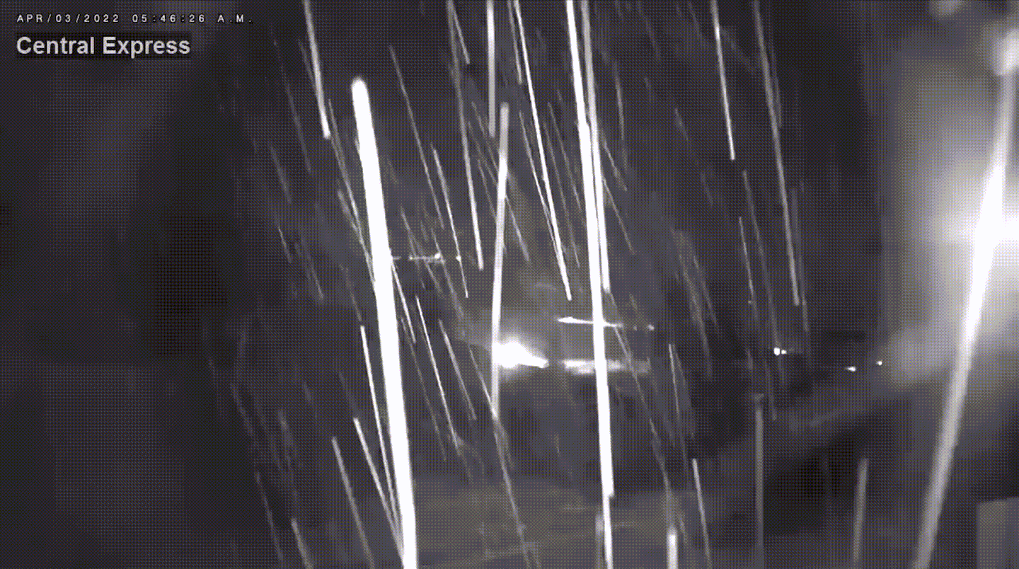
Snoqualmie Cam
Future Hurricanes
BTW, the cycling pattern has a direct link to hurricane activity. This year I am forecasting very light activity, after last year’s active season. I am forecasting 4 named storms. Possible locations and dates are Florida (Gulf Side) around August 14. New England around Sept 5 or 24th. and finally, a hurricane that will hit along the Texas coast around September 28th. It is possible that a hurricane could hit 62-64 days before any of those dates.
Forecast
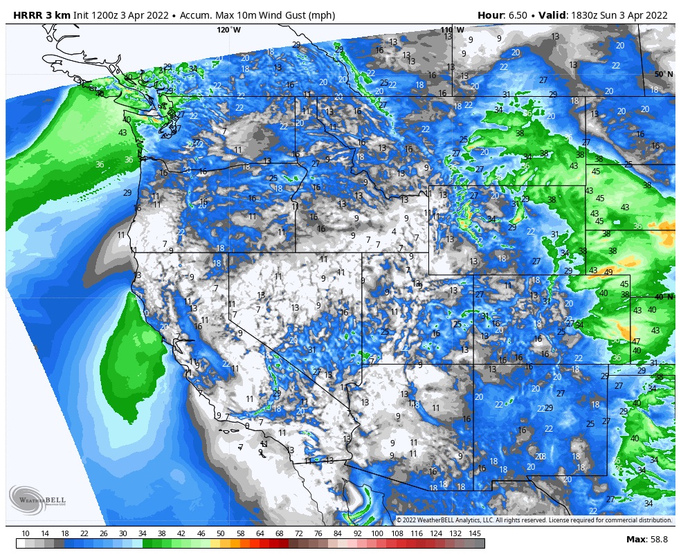
Wind Forecast
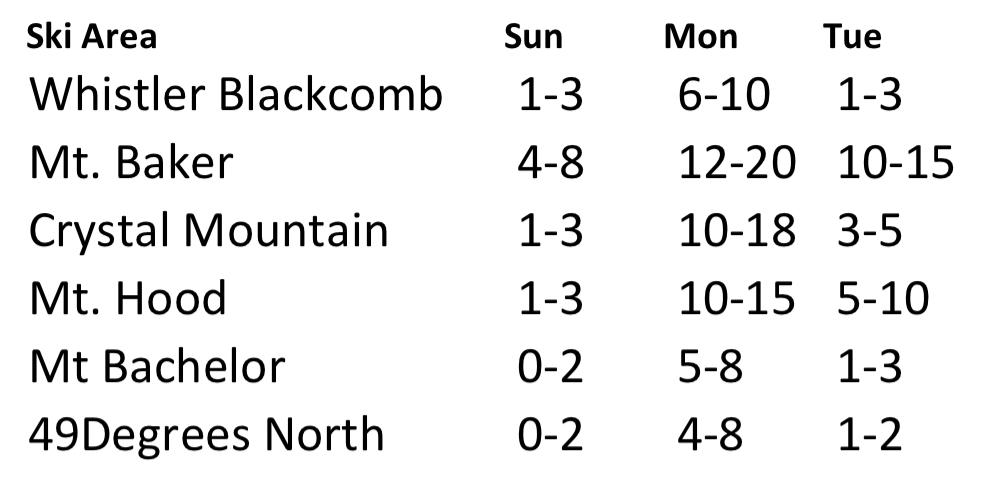
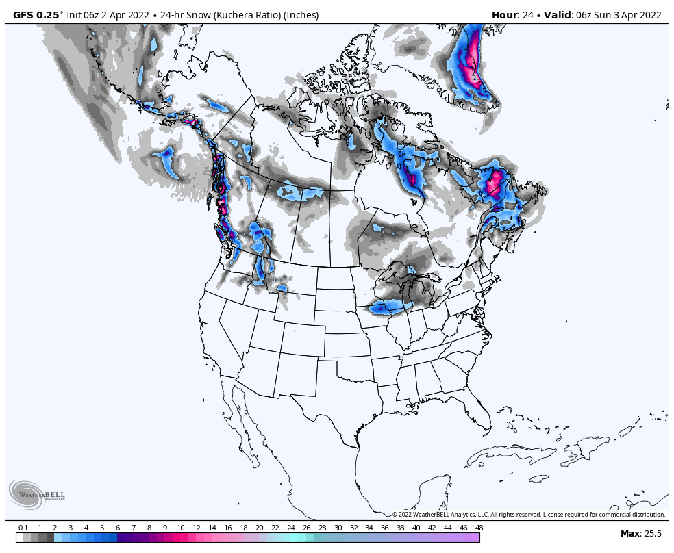
Heavy snow this afternoon and tonight for the Cascade mountains up to Whistler Blackcomb. Below is the expected snow totals. The snow will continue through Tuesday. Expect high winds at the passes and summits which will probably close upper mountain lifts.
Pattern Discussion (from yesterday)
Eight days remaining for the Northern Pattern before we return to the Active West. This next storm for Crystal Mountain, Mt Baker, Stevens Pass, Mt Hood and the rest of the PNW ski resorts is one of the better storms in the Northern Pattern. Each time producing an atmospheric river (AR). However, each time this storm came through in Cycle 1 and 2, it was too warm to make deep powder.
Most of you reading this time of year are die-hards, like me, and if you have been following along you understand the cycling pattern. Before this season, I had suspicions that ARs were predictable events, just like my colleagues Gary Lezak, Doug Heady, and others, use the Cycling Pattern to predict tornado outbreaks and hurricanes. Side Note, last year, FutureSnow accurately predicted Hurricane Ida in April–you can find that article here. So, with that ability to predict tornados and hurricanes, I wasn’t surprised that this particular AR repeated, I am surprised that it has for the 3rd time in a row! No way that is a fluke. So, lets dive in.
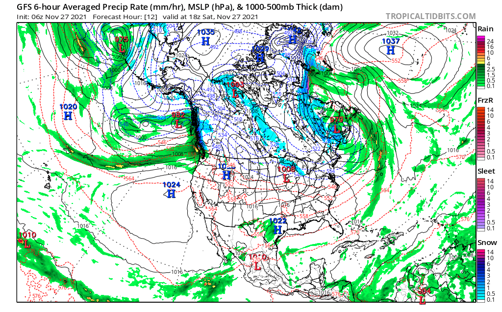
In Cycle 1, November 27th, there was an atmospheric river (AR) that extended over a thousand miles off the coast. Snow levels were at 12,000 ft, Seattle high temp of 54 that day, so all rain with over 1.5 inches.
Cycle 2, January 28th, again warm, another AR event, it was the backside of this storm that Mt Baker received 12, Whistler 10, Crystal 8 Mt Hood 8.
This time through, we have all of the elements to create a large dump, with another AR. We have cold air with falling snow levels Sunday night, base level highs at freezing, or below, at Whistler Blackcomb, Crystal, Stevens, and as far south as Mt. Hood Timberline and Meadows. We should be measuring snow totals in feet, not inches.
Look at the next series of charts and videos, you can clearly see the atmospheric rivers stretching out during each cycle. Also, watch the path of the storms, where it enters CONUS and exits.
Next, check out the GFS loop for today through April 18th. You can clearly see the northern pattern transitions back to the Active West (the 3rd storm with the U-Shape).
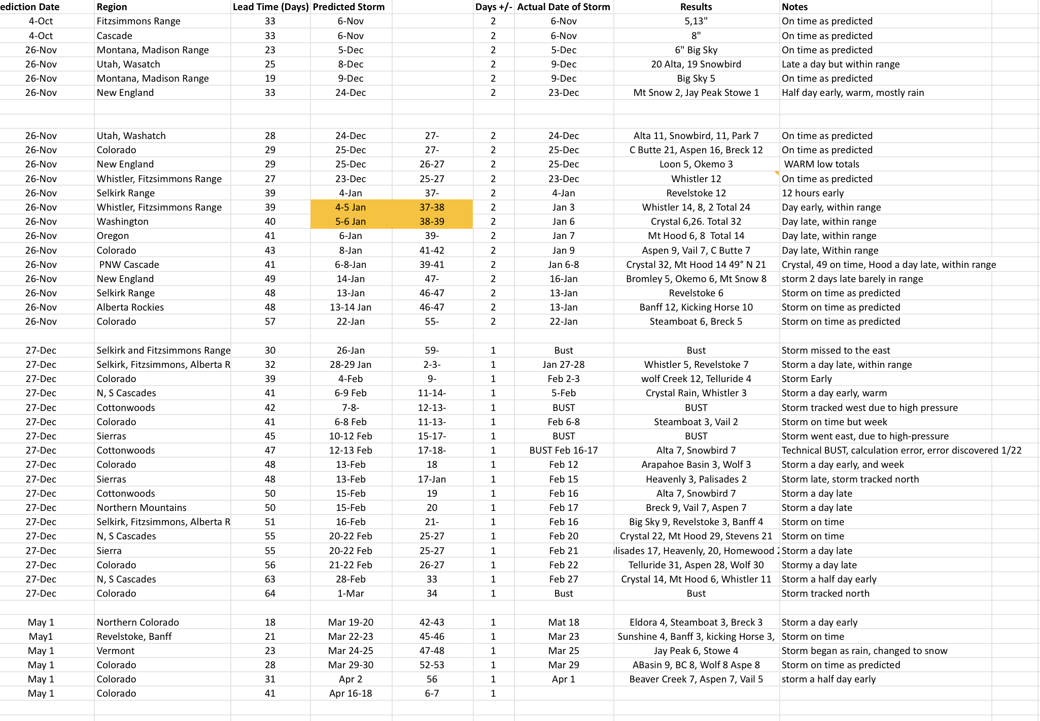
Prediction Chart Updated 88.4% Accurate (Avg lead time 29 days out)
We predict storms for many different regions to prove our theory. We have made 43 predictions this year 38/43, or 88.4 percent accurate. We made a calculation error with our second set of predictions that cost us our perfect record. We also had a minor calculation error that we call a “technical bust”, which I would love to count because that would get us to 90.7 %, beating last year’s average of 90.2%. The technical bust was still a bust, those things will happen–88.4 is still unheard of for long range forecasts, so we will take it.
We have one more storm on the chart left for April 16-18. That storm is showing up on the GFS and is trending early. We will keep an eye on it, the models do have the proper path we will see with the timing.

Thanks for your hard work!
That was DEEP yesterday! My legs are still burning. Thanks FutureSnow!