Pattern Discussion (200 level class)
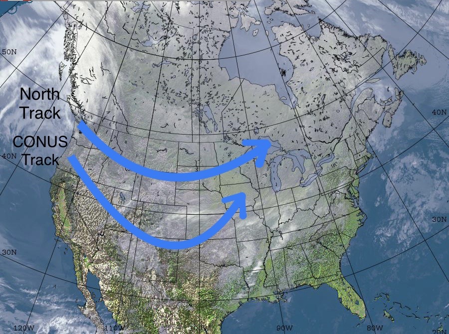
The first storm of the Active West (AW) pattern has been on the GFS for a few days now and enters the continental United States (CONUS) February 1. With the switch to the AW, both storm tracks, north track and CONUS track, are stronger and larger than the storms that come through in the Northern Pattern (NP).
There is less moisture during the NP, because the track of the jet stream flows off the coast of China, north towards Alaska, drying out along the way. The flow pattern is in place now for the switch back to the AW. Below is an animation of the jet flow from Net Weather.
During the AW pattern, the flow is more linear across the Pacific, drawing energy and moisture from warmer waters and frequently tapping into the pineapple express, a river of moisture from the tropical Pacific, also called an atmospheric river (AR).
This is a very active AR season with over 20 events and 4 major AR’s, most notably, in Tahoe October 24th, December 13th, and Seattle November 14 and Jan 6th.
There also seems to be a strong coupling of this year’s Pattern with the Arctic Oscillation (AO) and the North Atlantic Oscillation (NAO).
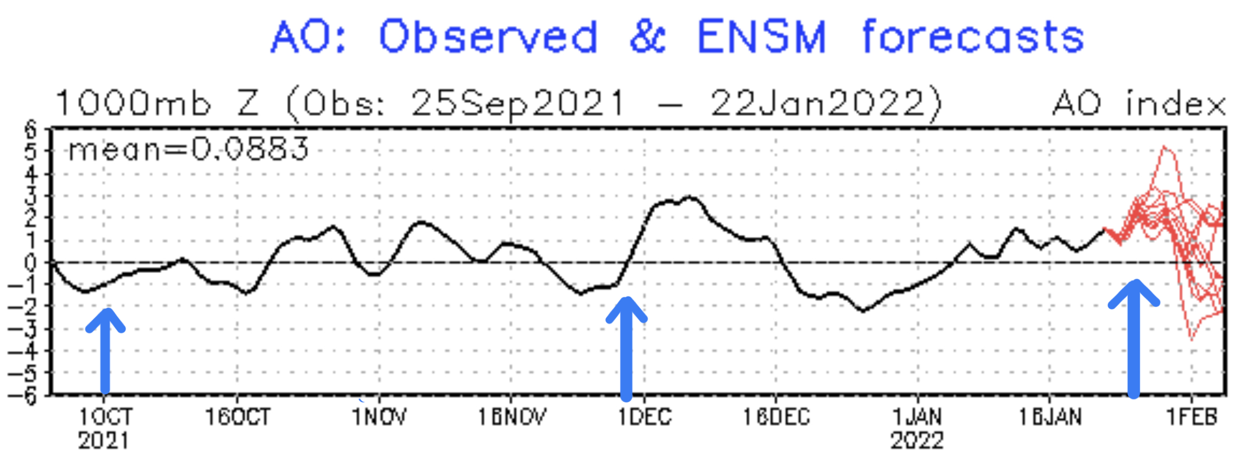
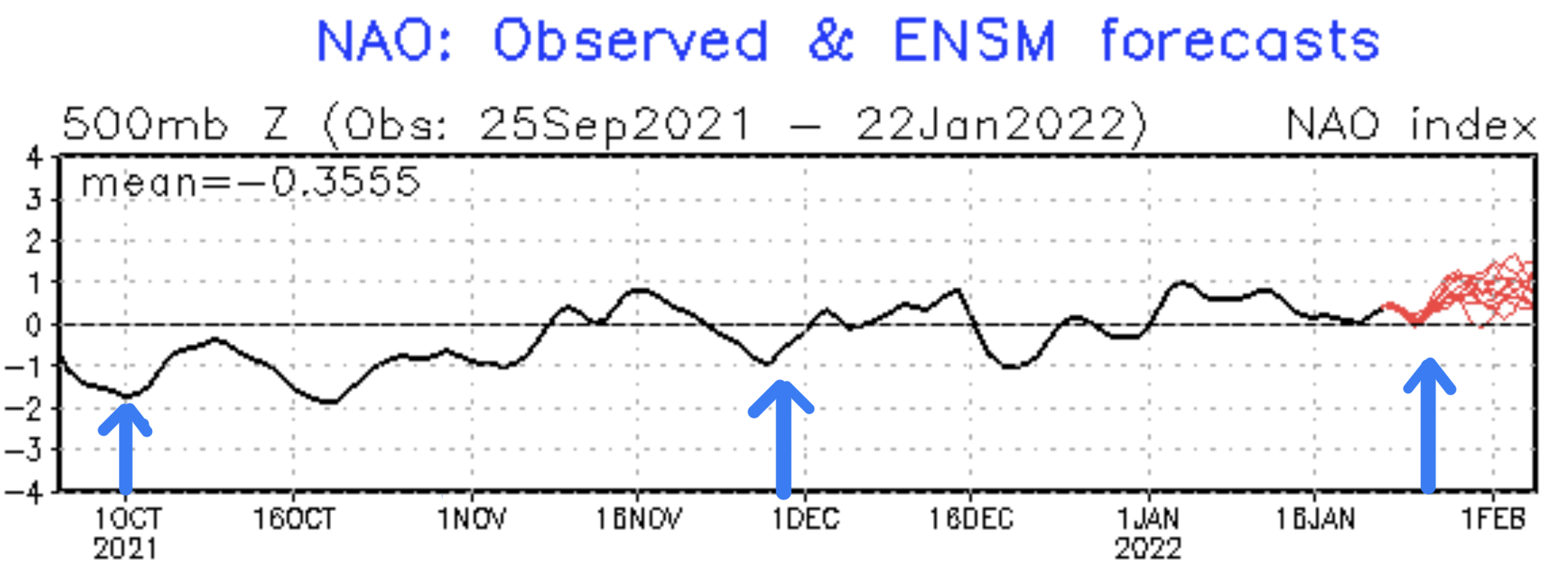
The arrows mark the cycles. In between the left arrow and middle arrow is cycle one, middle arrow to right arrow, cycle two. You can see with each transition from one cycle to the next, there is a fall in the indexes. One other interesting item is if you look to the right of each arrow, there is a rise and a peak. That is the Trifecta storm, which is coming up in a couple of weeks. If they are truly coupled, then will see a similar rise and peak, in the next couple of weeks.
The Trifecta kicks off the Active West pattern, but the real meat of the AW pattern comes on days 25-35, when the Trifecta is topped by the 4-pack. Four storms in 10 days. It seemed, in the first cycle, that the Trifecta was the largest storm. In the second cycle though, what looked like 2 good storms, 8 days apart, in the first cycle (with 2 small waves in between), grew into a huge 4 wave system that dumped feet of snow, seemingly everywhere. Here are the totals for the 10-day storm.
Colorado between 40-80
PNW between 50-81
Tahoe 130
Utah 50-70
It will be hard to top that series of storms in cycle 3. That 4 pack returns Feb 21st -March 2nd.
Forecast
Colorado
An Alberta clipper will move into Colorado Tonight moving from north to south. You can see from the animation the projected totals. Should be 4-6 for most mountains. Temperatures will be in the low teens Monday night rising to the mid 20s for Monday.
The models seem to be flip flopping on a solution, as earlier runs had the bulk of the system east of the divide, then west of the divide, now back to east. Last time thru, back in November, most mountains received 5-7 inches with Steamboat and Aspen coming in at 9. Below is a higher resolution model with 24 hr totals from the North American Model. I like this solution, over the others, I am favoring a middle, to western track based on the Pattern, so we’ll see how this plays out.

Next Pattern Storm
The next Pattern storm is the precursor to the Trifecta. It arrives Feb 2 in the PNW, Utah Feb 3 and Colorado Feb 4. That storm will take the CONUS track moving from northwest to southeast. It is on the models and on your Colorado and PNW calendars.
Thank you!
Thank you for spending time reading the blog. It is so fun to hear from all of you. Please take advantage of our Snow Concierge service. If you haven’t heard of this, you can read more below from our post last week. As always, if you have any questions feel free to comment below or email me to Mike@FutureSnow.CO
Presidents Day Forecast (Reprint)
Snow Concierge

Presidents Day is February 21st and we have been getting a lot of requests for things like, where to go? To, what is the forecast for Vail? We have a new service for these kinds of requests, we call it our Snow Concierge Service. With our Snow Concierge Service, you get a personal forecast for your destination. Or, if you’re not sure where to go, let us guide you to where the snow will be falling the week of your vacation.
Just send an email to Mike@FutureSnow.co with your vacation date, and destination, and we will give you the latest info and personal forecast. The best part is, it’s free.
Presidents’ Day Weekend
Colorado and Utah
Presidents’ Day falls during the Active West Pattern so there are a lot of choices for this holiday. The Trifecta is due before the holiday, so it should have a great kick start before the week leading up to Presidents’ Day. We will start at Valentine’s Day, and progress thru the week (pattern days 19-26). On days 19-20 in cycle 1, both Colorado and Utah resorts had snow with Alta having the most 11. In Cycle 2 Days 19-20, Alta wins again with 23. Colorado ranged from 5-12 with Steamboat the winner.
In both cycles days 21-23 had no snow. That gets us to days 24-26. Cycle 1: Utah, again the winner with Alta having 4-day totals of 21″. Colorado totals were minor 4-8. Cycle 2: Alta and Snowbird both with 20. Colorados Wolf Mountain had 14 and 12 and Aspen had 12.
Tahoe
Tahoe is a little trickier. Back in August and September, as the transition from last year’s pattern to this year’s, the storm path was mainly in Canada. However, there was one storm that stuck out as completely new. That storm hit August 18th and just grazed Lake Tahoe.
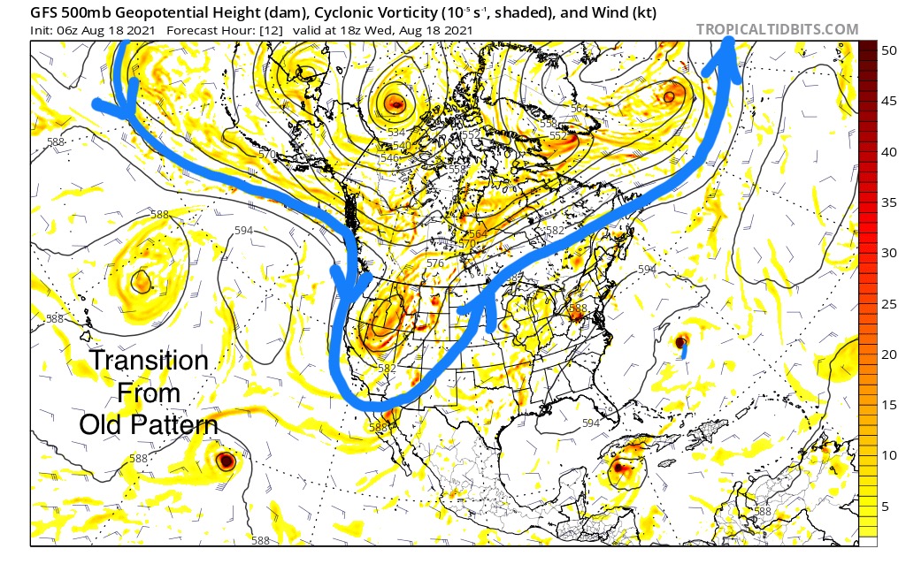 As a forecaster, you have to project how far south the storms will track as the jet stream lowers. Tahoe, I thought, was on the edge of the storms, based on that one back in August. In Cycle 1, Palisades Tahoe reported 8 on October 18th. but it was mostly a warm storm. Cycle 2, all of the elements came together for a huge storm dumping 75 inches in 5 days. That was the third wave of the Trifecta, and that storm wraps on day 19. In both cycles days 20-24 were dry.
Day 25. This was the Christmas Eve storm in Cycle 2, that we predicted based on what happened in cycle 1, October 25th–Tahoe 39 at Palisades. In cycle 2, day 25 kicked off a 9-day torrent of relentless snow that shut down and buried the resorts with 130 inches.
Pacific Northwest
October, in the Cascades, was warm and wet in the first Cycle, days 19-26, the only precipitation that was snow was reported at Mt Hood and Whistler Blackcomb (25-26). Cycle 2, it snowed 5 of the 7 days and Mt Hood Meadows received around 50 inches.
Rank ’em
If you haven’t picked your destination, you can’t really go wrong. Cycle 3 should be around the same strength as cycle 2. The storms have been trending late, however the lead-in storm, the Trifecta would just linger a day, or so, longer. There will be good snow everywhere, barring the unforeseen.
There are pros and cons to each destination. Will it be warm for resorts like Mt Rose, Donner Ski Ranch and Palisades in the Tahoe region? Same can be said for Crystal Mountain, Mt Hood and Stevens Pass. Utah and Colorado will most likely be colder. My choice is Utah, I will be at Alta, Snowbird and Park City, based on the best chance for quality of snow.
