Daily Snow Stakes

Surface Chart thru Feb 6th

All Snow Chart
 Forecast Summary
We have had a short break in snowfall for resorts in the west. Some places have had a little longer break than others, like Lake Tahoe, one snow in the last 16 days, but they are used to “feast or famine”. The breaks this year are certainly better than last year–so we can’t really complain.
The Active pattern is beginning to crank back up this weekend, starting today in the Pacific Northwest and tomorrow night in Lake Tahoe.
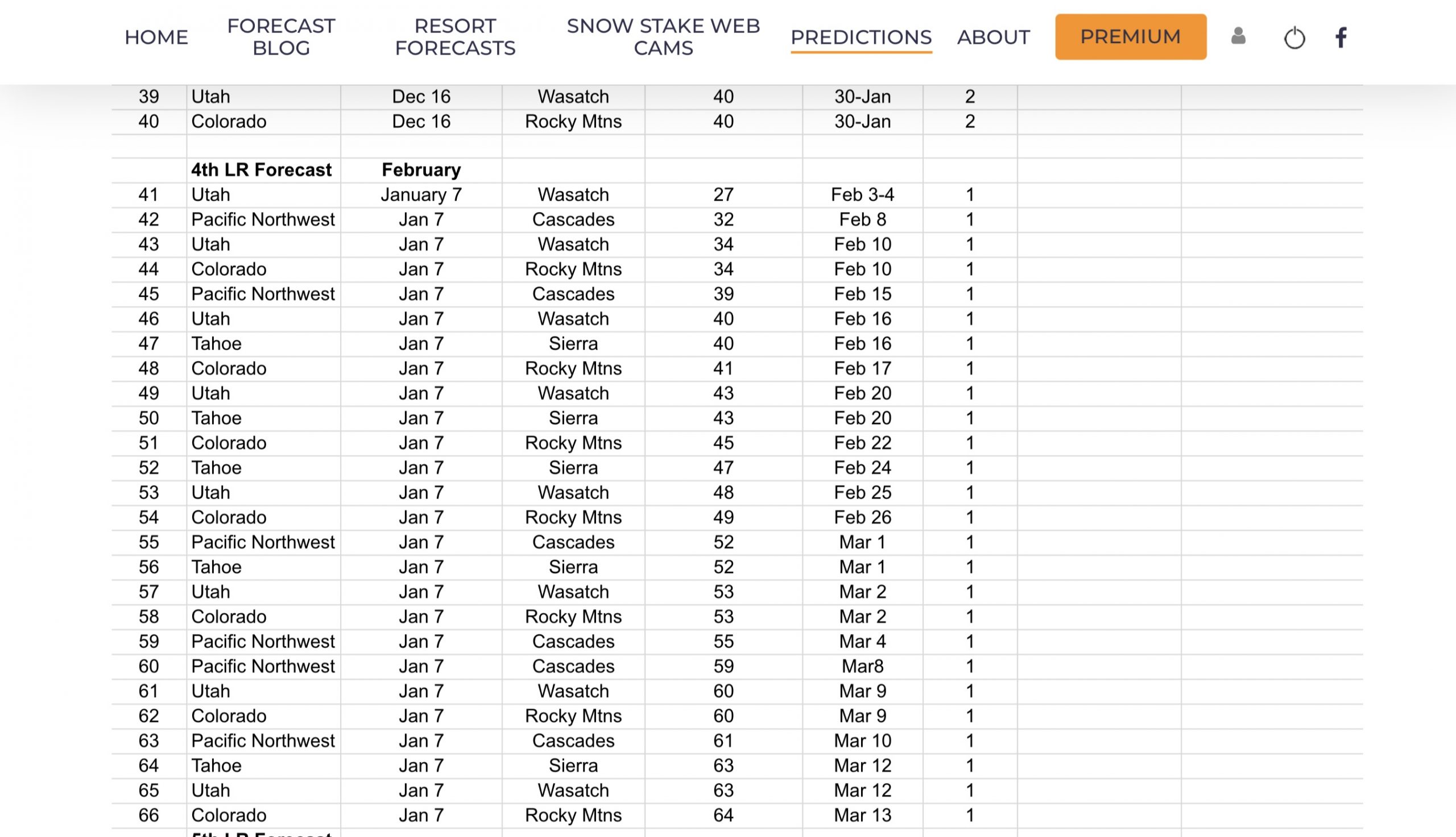
Storm 41, on the Long-Range Prediction Chart (LRPC), will impact the Cascades today, followed by a secondary wave that will bring snow to the Sierra Saturday night, reach Utah by Sunday, finally Colorado by Sunday night.
Storm 42 is shaping up to be a small atmospheric river, that will slide down the British Columbia coast next Thursday evening. This storm is shaping up to be weak, through Utah and Colorado, until it gets to Texas and then, Boom! Snow in the panhandle to possibly all the way to Dallas.
That would be another snow/sleet, or ice storm event sure to make national headlines. This storm will change as it is still 138 hours away from the coast of Seattle. It does appear to have the potential to strengthen for the Southern San Juan mountains and Taos.
Forecast
PNW


Snow returns to the Cascades today with temperatures in the 30’s with strong winds20-25, with 40 mph gusts. Crystal Mountain, Mt Baker, Mt Hood, and Hoodoo above 6000 ft will receive 3-5 throughout the day today with another 3-5 tonight. The rest of the resorts, Stevens Pass, Mt Bachelor and Bluewood will receive 1-3 today and 2-5 tomorrow.
Tomorrow, temperatures will be similar to today but less windy. Winds will be the strongest in the northern Cascades between 10 15, with light winds in the southern Cascades.
Lake Tahoe

Today will be partly cloudy with temperatures in the lower 30’s with moderate winds between 15-20 mph with gusts near 40. There is a fast-moving wave going through that might bring a quick shot of snow, but not much, if any, expected.
Tomorrow will be warm with some sunshine likely. Temps in the lower 40’s, with winds similar to today.
Tomorrow Night, we get cranking. Snow moves in and will be heavy, with cold temperatures in the mid 20’s, perfect for making soft snow for Sunday morning. Right now, the bullseye looks to be at Kirkwood, Mammoth and Dodge Ridge.
 Sunday, Powder Day with temperatures starting out around the mid 20’s and topping out near 30. Winds will still moderate, 15-20 but gusts are a reasonable 30 mph. Snow continues throughout the day and will end shortly after the lifts close
Utah,

Not much happening until Sunday. I’ll breakdown the forecast tomorrow.
Colorado

Storm arrives Sunday night, details forthcoming.
Lake Tahoe Calendar

Below is the Long-Range Forecast Calendar for Lake Tahoe through March. Yellow Boxes indicate that a storm came through in 1 Cycle. For the upcoming cycle, yellow boxes will carry a 50% chance of occurrence. Those percentages will increase once we get though another cycle, and I will update the calendar accordingly.
Green Box indicates that a storm came through in both cycles and is predicted to repeat.
As you can see by the chart, I am gambling with all of the yellow predictions. Also, I missed 1 prediction for March 21st, so I added it to the long-range.
Thank you for reading the blog, as always, if you have any questions, or need personalized info for trip forecasts, please email me at Mike@FutureSnow.co
Long-Range Forecast Predictions thru March
 Forecasted Areas
Pacific Northwest Cascade Mountains
Crystal Mountain, Mount Hood Meadows, Timberline, 49 Degrees North, Bachelor, Mt Baker,
Lake Tahoe Sierra Mountains
Heavenly, Palisades Tahoe, Kirkwood, Dodge Ridge, Donner Ski Ranch
Utah Wasatch Mountains
Alta, Park City, Deer Valley, Brighton, Snowbird, Brian Head
Colorado Rocky Mountains
Aspen, Aspen Highlands, Snowmass, Vail, Beaver Creek, Winter Park, Keystone, Arapahoe Basin, Breckenridge, Copper Mountain, Powderhorn, Ski Cooper, Telluride, Crested Butte, Silverton, Wolf Creek, Eldora, Loveland
–
