Daily Snow Stakes

Pattern Discussion
There was a great question, in the comments section of the blog yesterday, I also had an email regarding a simlar topic, a while back. This is from TomGos “…I wondered if you are also looking at accuracy, in terms of notable snowfalls, that occur that you had not predicted”?
A similar question came from an email, NLTCrow writes “Neither of our 2 big 3-5 foot storms this year, on Nov 8 and Dec 10-11, were on your predictions list. As a skier yourself, you’ve gotta agree that missing both these 2 whoppers is way worse than making a 6-inch prediction that fails. And the 2 storms that are on there for this month have pretty much fizzled”.
NLTCrow is absolutely right, we have to get better at predicting storms for Tahoe, and it goes to the heart of what TomGos asked. Notable snowfalls that we didn’t anticipate, or don’t make it on the prediction forecast.
We are incredibly accurate at predicting storms that follow the jet stream. I have mentioned many times that Tahoe is on the edge of these storms, because the jet stream is usually on the edge. Some storms are so large that they repeat, regardless of the main jet flow. Those always make it on the Long-Range Forecast Predictions (LRFP).
This year, we have a strong influence from the Madden Jullian Oscillation (MJO) and I noticed a pattern that when the MJO was in a favorable place, storms would be bigger. Vice versa, when the MJO was in a neutral position, the storms were weaker. This is not groundbreaking as many have made this correlation. However, it does possibly answer why Tahoe would have, seemingly, wildcard storms that did not recur regularly, like the rest of the LRC (Lezaks Recurring Cycle).

The possible correlation of the MJO and wildcard storms got me thinking about last year. We had a great second cycle, huge storms similar to this year, then poof, the rest of the year was ho-hum. I went back and looked, sure enough the MJO was in phase 6, 7 and 8 during that great cycle.
Let’s look back to last year and break down the strong second cycle and weak cycle 3 of last year. I just copied this from a spreadsheet, so I apologize that it doesn’t look better–both charts are for the same cycle days, the first is cycle 2 followed by cycle 3. The blue numbers represent the day of the cycle.
Last Year Lake Tahoe Cycle 2 and 3
Cycle 2 2021-22
| 13-Dec | 14-Dec | 15-Dec | 16-Dec | 17-Dec | 23-Dec | 24-Dec | 25-Dec | 26-Dec | 27-Dec | 28-Dec | 29-Dec | |||||
| Day 10 | 11 | 12 | 13 | 14 | 15 | 16 | 17 | 18 | 19 | 20 | 21 | 22 | 23 | 24 | 25 | 26 |
| 21 | 29 | 9 | 14 | 3 | 10 | 26 | 11 | 26 | 30 | 9 | 4 | |||||
| 16 | 25 | 18 | 17 | 1 | 9 | 14 | 4 | 23 | 20 | 12 | 3 | |||||
| 12 | 25 | 5 | 10 | 2 | 8 | 5 | 4 | 20 | 23 | 6 | 2 |
The above spreadsheet of last year’s snowfall tracking, for Lake Tahoe resorts, shows the tale of the tape. In cycle 2, there is a two-wave storm that hit Dec 13th thru 17th, and another series of storms that hit Dec 23rd thru the 29th. The chart below shows what happened in cycle 3 January 17-February 2. Noticeably different results in snowfall.
Cycle 3 2021-22
| 7 | 10 | 5 | ||||||||||||||
| 16 | 8 | 4 | ||||||||||||||
| 9 | 8 | 6 | ||||||||||||||
First, let’s look at the surface charts and look at each storm. Below is the comparison of the first two systems. In the first chart (click to enlarge), look at the position of the High-pressure area and then compare that to the second chart. That is the first difference. Next is the Madden Jullian Oscillation (MJO). In the first chart, the MJO is in phase 7, the second chart the MJO is neutral and moving towards phase 3. For the rest of the ski season, the MJO would not enter phases 6-8 again.
Back to that High-Pressure location. The Artic Oscillation (AO) is the difference between the High in the two charts. In the first chart, the AO was neutral and dove negative for the last 5 days of the selected period. In the second chart, the AO was strong positive causing the jet stream to steer the storms northward.


Now let’s breakdown the second two charts. The first chart is in Cycle 2 and because of the aforementioned teleconnection settings, the storms are steered by the mid-level jet stream right into Tahoe. The storms have more energy due to the MJO.
Second chart is Cycle 3, where the jet stream is affected by the positive AO. The jet pushes storms 2 and 3 north and east of the Lake, missing Tahoe entirely. While the neutral MJO does not enhance moisture, making the storms weaker.

That is why it is so hard to predict storms for Lake Tahoe. It is the jet stream that moves the storms into position, the AO steers the jet stream and the MJO seemingly adds to the strength of the storms. Until we can better predict what the AO is going to be beyond 10 days out, we are stuck just like ordinary forecasters. The MJO is a little easier to predict beyond 10 days, so we can factor this into forecasting for Tahoe.
We have plenty of data to predict all of the storms for Lake Tahoe, so I will go through and make a Lake Tahoe storm chart. We will use the data from each of the last two cycles to compile a list of storms that repeated and storms that occurred in 1 cycle. The recurring storms will have priority and the wildcard/MJO storms will be listed at a 50% chance of occurrence, because it hit in 1 out of 2 cycles. Once we get finished with cycle 3 then we can give it a 33 or 66% chance and so on.
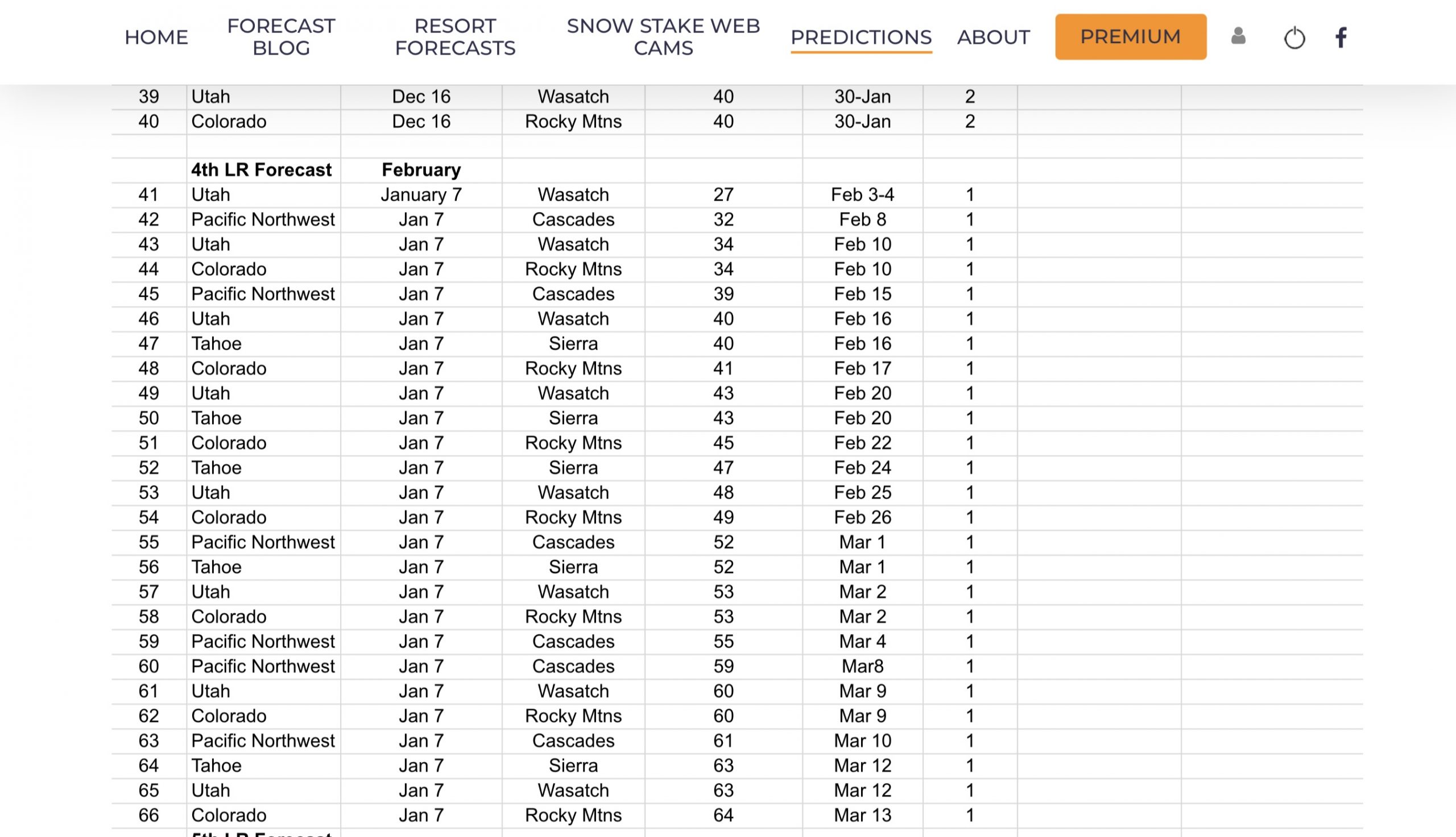
Lake Tahoe Calendar
Below is the Long-Range Forecast Calendar for Lake Tahoe through March. Yellow Boxes indicate that a storm came through in 1 Cycle. Green Box indicates that a storm came through in both cycles and is predicted to repeat.
As you can see by the chart, I am gambling with all of the yellow predictions. Also, I missed 1 prediction for March 21st, so I added it to the long-range.

Thank you for reading the blog, as always, if you have any questions, or need personalized info for trip forecasts, please email me at Mike@FutureSnow.co
Long-Range Forecast Predictions thru March
 Forecasted Areas
Pacific Northwest Cascade Mountains
Crystal Mountain, Mount Hood Meadows, Timberline, 49 Degrees North, Bachelor, Mt Baker,
Lake Tahoe Sierra Mountains
Heavenly, Palisades Tahoe, Kirkwood, Dodge Ridge, Donner Ski Ranch
Utah Wasatch Mountains
Alta, Park City, Deer Valley, Brighton, Snowbird, Brian Head
Colorado Rocky Mountains
Aspen, Aspen Highlands, Snowmass, Vail, Beaver Creek, Winter Park, Keystone, Arapahoe Basin, Breckenridge, Copper Mountain, Powderhorn, Ski Cooper, Telluride, Crested Butte, Silverton, Wolf Creek, Eldora, Loveland
–
