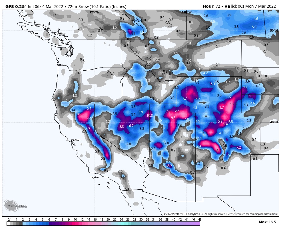
Forecast Summary
The snow begins to fly this morning from Tahoe to Utah. Colorado joins the show in this afternoon. We have been talking all week that this storm begins warm and ends cold and nothing has changed. This system is predominantly a 3-wave storm, which can be seen on the region-specific animations below.
Forecast
Tahoe
Snow begins this morning to early afternoon depending on location. It still looks like the crest and the west are best, with Kirkwood and Dodge Ridge favored today, as the storm is moving in from the southwest. Snow levels begin the day around 7000 ft and will lower throughout the day settling around 5000 ft tonight. Expect high winds as the front rolls through with gusts up to 35 mph. Expect 4-8 today for Kirkwood and Dodge Ridge, with Donner Homewood and Palisades in the 2-4 range.
Tomorrow
Much colder with a high around 25. Winds from the southwest from 15-20 with gusts up to 30. Wind chills in the single digits to 0. Most resorts will pick up another 2-4.
Utah
Snow arrives this morning around 11. Warm temps in the morning lowering throughout the day with moderate winds from the southwest 12-15 mph. There won’t be much precipitation until late in the day when the second wave moves in. I am expecting 2-4 overnight for Alta, Brighton and Snowbird.
Tomorrow
Colder, with southwest winds 14-17 mph. Total snowfall throughout the day will be 2-4 with the bulk of the snow falling after the lifts close. Expect overnight snowfall in the 5-10 range. Best day for powder will be Sunday.
Sunday
Powder Day! Final wave of snow comes through. Expect another 4-8 throughout the day wrapping up after the lifts stop spinning. There will most likely be lingering orographic snow overnight and into Monday morning, but I am expecting the storm to be over by Sunday evening. Monday will be a great day as well.
Colorado
Storm rolls in with the first wave in the early afternoon hours. The southern mountains will be favored with the storm moving in from the southwest. Telluride, Silverton, Wolf Mountain and Purgatory look to have snow totals in the 20’s, by the end. The central, I-70 and northern mountains get going after the lift’s close tonight. I expect 4-8 for the San Juans today with the bulk of that occurring tonight. For the central mountains, I am expecting 2-5 with perhaps a surprise or two, and again, most snow will fall overnight. I-70 and northern mountains 2-3.
Tomorrow
A lull in the intensity as the next wave hits Saturday night. Expect warm temps before a cold front arrives during the evening hours. I am expecting 1-3 for daytime snow, and that may be on the high side, with the bulk of the snow falling in the evening. 3-5 for the San Juans with most other resorts in the 2-4 range.
Next Storm
The next pattern storm is a clipper system that hits the PNW on Tuesday, Utah and Colorado Thursday. It is right on time and is one of our Spring Break storms. Below is a 2-Day Snowfall Chart.

