


Forecast Summary
Snow today from the southern Cascades down to Lake Tahoe, Utah and Colorado. This system will move out of Tahoe tonight, early tomorrow morning in Utah. Colorado gets going today with the first round of energy hitting the north central part of the state. There will be a second wave of moisture, that will bring reinforcements on Tuesday. You can see this second wave of energy below.

Here is an animated GIF from the 500 millibar level, so you can see how it moves. This chart is the wave energy from about halfway up in the atmosphere. It is the best view of the cycling pattern.

Forecast
 Washington
Today
Bluebird skies today with temperatures in the upper 20’s and moderate winds. No major accumulation is expected until Thursday when the next system moves in.
Oregon
Today
Some snow showers possible this morning, but the main energy is long gone. Skies will clear this afternoon bring temperatures up around 30 with light winds. The next system moves in Thursday.
Tahoe
 Tahoe gets its second wave today as the Snow Show continues. Temperatures near 30 with moderate winds and 25 mph gusts. Expect 4-8 throughout the day for Boreal, Donner Ski Ranch, Sugar Bowl and Palisades. Expect 2-4 for Kirkwood, an inch or two at Mt Rose and Heavenly.
The storm moves out this afternoon. Tomorrow will have scattered snow showers with light winds and temperatures near 30. The next system moves in early Friday morning.
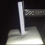
Utah

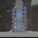
Snow today with highs in the low 20s, with light winds. Wind chills will be near zero, so dress warm. I am expecting another 2-4 for Alta, Snowbird and Brighton today with 1-3 for Park City. The storm moves out in the early evening.
Colorado
 Today, the bulk of the storm will be in the north near Steamboat and will slowly move south southeast. Reaching Aspen and Crested Butte tonight.
The second wave of energy moves in on Tuesday, adding to the totals and bringing snow to the East and Southern mountains, Telluride, Silverton and Powderhorn. Temperatures will be warm during the day, in the mid 30s today dropping to the upper teens overnight. Moderate winds 10-15 mph. Below is the expected snowfall.
FutureSnow Subscription
We are launching our subscription service next week. I hope all of you will join us as we move into this next phase. We will continue to give you the best service that we can deliver. There is more to come on this, I will discuss that on Monday.
 Thanks for reading the blog, as always if you have any questions, please ask in the comments below or send an email to Mike@FutureSnow.CO
Forecasted Areas
Pacific Northwest Cascade Mountains
Crystal Mountain, Mount Hood Meadows, Timberline, 49 Degrees North, Bachelor, Mt Baker,
Lake Tahoe Sierra Mountains
Heavenly, Palisades Tahoe, Kirkwood, Dodge Ridge, Donner Ski Ranch
Utah Wasatch Mountains
Alta, Park City, Deer Valley, Brighton, Snowbird, Brian Head
Colorado Rocky Mountains
Aspen, Aspen Highlands, Snowmass, Vail, Beaver Creek, Winter Park, Keystone, Arapahoe Basin, Breckenridge, Copper Mountain, Powderhorn, Ski Cooper, Telluride, Crested Butte, Silverton, Wolf Creek, Eldora, Loveland
