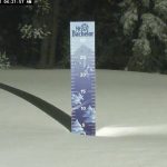
Overnight Totals
Crystal 10, Mt Hood Timberline 13, Stevens Pass 7, Mt Baker 6, Revelstoke 6
Forecast Summary


Winter Storm Warning for Washington (ends 10 am)

Washington Today
Today, the storm wraps this morning and bluebird skies will prevail this afternoon. Light winds and cool temperatures in the low 20’s. The next system moves in Tuesday evening.
Oregon
 Snow today, 2-4”with high winds (40 mph Gusts), and bitter cold with temperatures falling to the teens this afternoon, with wind chills as low as -15, yes negative 15! That’s 1 run and in for a warmup. Mt Hood Timberline is going to try to open today, check the website if your going up. I want to hear from you if you do send an email to Mike@FutureSnow.co.
Mt Hood Meadows is planning on opening tomorrow, Mt Bachelor Wednesday.
Next Storm arrives tomorrow afternoon/evening, likely after the lifts stop spinning. We are looking at 6-10” before first chair Wednesday, with snow all day with additional accumulations, around the foot, by Thursday night. Again, it’s going to be windy, however, at the present it looks like only 20-30 mph.
Utah

The storm will be moving in this morning around 8 AM. Temperatures falling throughout the day settling on the upper teens with moderate winds with windchills around 0. Daytime accumulations today in the 5-9 range for Alta, Snowbird, and Brighton, with 3-5 likely for Park City. Expect an additional 2-4 overnight.
The next system moves in Thursday afternoon/evening.
Colorado

Today
The storm moves in this afternoon around 2 o’clock. The heaviest precipitation will fall after the lifts stop running. Presently the bull’s-eye looks to be around steamboat, I’m expecting 2-day storm totals around 8-12 for Steamboat, 6-10 Vail/Beavercreek, 5-8 Aspen, 4-6 Breckenridge, Keystone and Arapahoe Basin.
The western and southern mountains, Powderhorn, Telluride, Wolf and Silverton, expect totals to be in the 4 to 8 range.
Tuesday
Snow throughout the day ending around 3-4 o’clock for most mountains. Cold temperatures in the low 20’s with wind chills around the single digits.
Next system hits Thursday night.
Long-Range Forecast thru December 21st

Subscription service begins in December.
 Forecasted Areas
Pacific Northwest Cascade Mountains
Crystal Mountain, Mount Hood Meadows, Timberline, 49 Degrees North, Bachelor, Mt Baker,
Lake Tahoe Sierra Mountains
Heavenly, Palisades Tahoe, Kirkwood, Dodge Ridge, Donner Ski Ranch
Utah Wasatch Mountains
Alta, Park City, Deer Valley, Brighton, Snowbird, Brian Head
Colorado Rocky Mountains
Aspen, Aspen Highlands, Snowmass, Vail, Beaver Creek, Winter Park, Keystone, Arapahoe Basin, Breckenridge, Copper Mountain, Powderhorn, Ski Cooper, Telluride, Crested Butte, Silverton, Wolf Creek, Eldora, Loveland

