Posted March 14 7:18 am PT 6:18 am MT
Pattern Discussion
A brief look at the current teleconnections as it relates to our current weather from the Climate Prediction Center. If you are interested in checking out this site for yourself you can bookmark this link: https://www.cpc.ncep.noaa.gov/products/precip/CWlink/daily_ao_index/ao.shtml
This is my go-to site for current readings. You can find reports for ENSO (El Nino Southern Oscillation), or click on the Sitemap tap, and you’re in for hundreds of topics they cover.
El Nino Southern Oscillation

It’s official, we are in neutral ENSO conditions. This was expected, we will continue to watch to see how far this goes. Will we have an El Nino next winter? The CPC has stated that “from November ’22 to mid-February ’23, negative anomalies weakened and returned to near zero. Since then, anomalies have become positive and are increasing.” Since October 20th, the switch was flipped, in my view, to an El Nino like pattern.
AO (Artic Oscillation) PNA (Pacific North American) NAO (North Atlantic Oscillation)


Pattern Comparison (from yesterday)
I have put together this year’s version of the MSLP (Mean Sea Level Pressure) surface compilation to show the pattern in action. It is not difficult to see, but I do want to point out that there are differences, teleconnection wise, between the two cycles.
The compilation lasts the entire length of the cycle, 50 days. The actual cycle length is closer to 49.3 days, which we have taken into account for 0ur next set of predictions that will be out Wednesday.
Seasonal Differences
Upper Pane
In the upper pane is from the fall, from Oct 30 thru Dec 18th. the lower pane is winter, Dec 18- Feb 6th. There are seasonal differences between fall and winter, that is obvious, but the main point is the strength of the jet stream is strongest as we get into February. It is expected that storms in October and November will generally be weaker than storms December thru February.
I choose these dates because it is easier to see the pattern when it is amplified. There are 3 types of patterns, weak, regular and amplified. In the upper pane, the pattern is amplified until November 10th and then turns weak. You will notice weak storms following the jet stream, those are pattern storms and come through regardless of the strength of the pattern.
The pattern switches back to “amplified”, Nov 30th. When the pattern is amplified, the storm door to Lake Tahoe is opened and the pattern storms that normally follow the jet stream are bigger and storms (waves) that are 3-4 days apart grow together.
Lower Pane
In the very beginning of the clip, the pattern is regular, but quickly becomes amplified within a few seconds, as wave after wave of atmospheric rivers (AR) flow into the west coast. This is full-on winter with an amplified pattern and strong jet stream.
Jan 20th, the pattern flips to regular, then weak by Jan 23rd. You will notice the position of the High-pressure area during the weak point. The High is part of the Artic Oscillation (AO). When the AO is strong positive, the jet stream steers storms northward, allowing for warm air to move in. The storms are squeezed of moisture but still flow on time.
Music by Tiredeyes and can be streamed for free at Tiredeyesmusic.com
Snow Stake Cams


GFS Surface Map
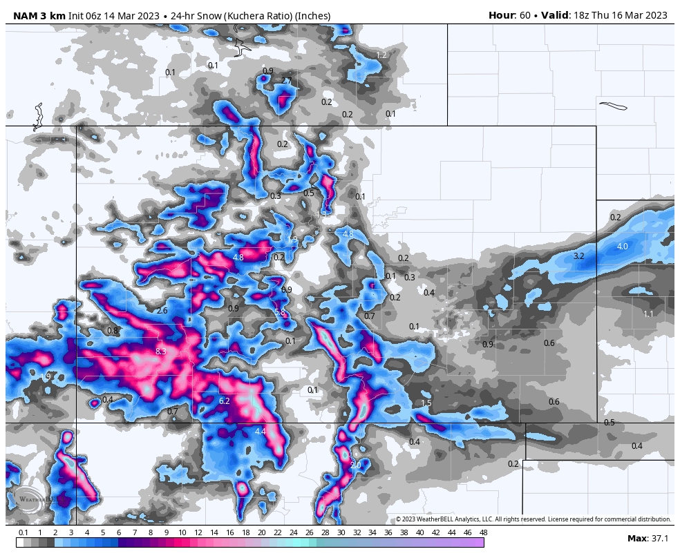
 All Snow High Res HRRR

Forecast Summary
Lake Tahoe, heavy snow is expected to continue throughout the day and evening where we could end up with 4 feet in 24 hours along the crest. Relentless heavy snow, and rain below 6000 feet, will continue through Wednesday mooning. Cold temperatures Tuesday night will lead to soft snow for Wednesday. Wednesday looks like the best day to ride, if the resorts can dig out in time.
In Utah, the next system moves in this afternoon with the stronger wave coming through later tonight. Expect a nice powder day Wednesday, with heavy snow throughout the day with 12-20 likely, for the higher elevation resorts.
Temperatures will start out on the warm side Wednesday, at base level, but will crash during the afternoon, along with snow levels. Temperatures will be in the mid 20’s by 2 pm and down to the low teens overnight.
Colorado gets in on the action tomorrow, as early as 11 am. Temperatures start out warm, in the low 40’s in some spots, before falling throughout the day. Looking at upper-level temperatures, a nasty mix is likely, so be prepared and bring your squeegees. It should be all snow above 9000 feet,

Click to Animate

Utah

Today
Today expect a mix of sun and clouds with temperatures in the low 30’s at base level. The storm moves in this afternoon, around 3, and we could see a couple of inches before the lifts close. Moderate winds between 15-20 early and increasing in the afternoon as the front approaches. Expect afternoon gusts in the 40 mph range.
Tonight
Full on nuking is expected throughout the night with heavy totals between 1-2 feet. Temperatures will be warm at base level, but upper mountain temps will be in the low 20’s.
Tomorrow
Heavy snow throughout the day with some thunder mixed in. Temperatures will fall throughout the day and settle in the low teens at base level overnight. Strong winds between 25-30 with 50 mph gusts.
 Colorado

The models don’t have a very good handle on the totals. Here is a sampling of the different outcomes predicted as of this morning.


 Today
Today
Sunny and warm today. Temperatures will be in the low 40’s with light winds for most of the day, with the exception of the divide, where we could see gusts in the low 30’s.
Tonight
A small wave will come through tonight, with little or no precipitation expected.
Tomorrow
Snow arrives in the morning to afternoon from west to east. Temperatures start out warm but will start falling by 2-3 pm. the heaviest snow will occur after the lifts close. Winds will be somewhat strong, between 15-25 mph with 45 mph gusts.
Thursday
Heavy snow expected throughout the day. Temperatures will be in the low 20’s with moderate winds between 10-15 mph with 25 mph gusts.
Daily Snow Stakes


Please Email with Suggestions
This website is for you. I don’t like surveys, but occasionally I do fill them out, when I care about the subject matter. I would like to know what you like, dislike, or what you would like to see more of, such as more charts, more science, more extensive forecasts, etc. Anything to make this site better.
We have a lot of things we are planning on adding this summer. We are going to do an extensive upgrade to add automated features like resort current conditions, add all the webcams that we can process., along with some back of the house items.
What else do we need? Email me at Mike@FutureSnow.CO
Long-Range Prediction Chart
We are on storms 60-64 that will occur this week. Presently, we are in a lull with the strength of the storm systems, but that is predicted to energize in the coming days. We are seeing this energy on the models, around storm 64, for Lake Tahoe, with the aforementioned AR that is setting up now.

Colorado, Utah and Pacific Northwest Calendars


Forecasted Areas
Pacific Northwest Cascade Mountains
Crystal Mountain, Mount Hood Meadows, Timberline, 49 Degrees North, Bachelor, Mt Baker,
Lake Tahoe Sierra Mountains
Heavenly, Palisades Tahoe, Kirkwood, Dodge Ridge, Donner Ski Ranch
Utah Wasatch Mountains
Alta, Park City, Deer Valley, Brighton, Snowbird, Brian Head
Colorado Rocky Mountains
Aspen, Aspen Highlands, Snowmass, Vail, Beaver Creek, Winter Park, Keystone, Arapahoe Basin, Breckenridge, Copper Mountain, Powderhorn, Ski Cooper, Telluride, Crested Butte, Silverton, Wolf Creek, Eldora, Loveland
