Daily Snow Stake


Surface Chart
 All Snow Chart

Forecast Summary
Heavy snow today in the pacific Northwest, as Storm 45 gets cranking. The storm is running about a day early. Meanwhile, the cut-off Low system is sliding across the southwest and reaches southern Colorado by this afternoon. That will bring heavy snow to the San Juans, and Taos Ski Valley. Taos needs the moisture as they are one of the few resorts in the west with below average snowpack (81%).
The Low is taking a better-than-expected path through Colorado and will spread through the central, northern and resorts along the divide, by this afternoon and evening.
On the heels of the Cut-Off Low, is the Pacific Northwest storm. It reaches Utah Tonight, around midnight, and will move into Colorado Wednesday. You can see the storm a little clearer with the 500 mb level. Watch the trough dig into where the Low exits.

Forecast
PNW

Heavy snow today in the Cascades with Winter Storm Warnings issued for Stevens Pass and all of the Oregon resorts. Temperatures in the low 30’s and falling throughout the day. Winds are mixed, with moderate speeds in the northern Cascades and strong winds in the southern Cascades.
For Oregon resorts, expect steady winds from the west, in the upper 30’s to 40’s with 60 mph gusts at Mt Hood. These wind speeds will definitely close upper mountain operations at Mt Hood. I would search for wind protected areas, such as Heather Canyon at Meadows. The winds will not be as strong for Mt Bachelor, but gusts will still have a lot of bite to them–around 45 mph.
Tomorrow
This will be the best day to ride powder. Temperatures will be in the lower 20’s with light to moderate winds. Expect scattered snow showers, at a minimum with a few more inches likely before the lifts open.

Utah


Colorado


Storm History
We had a strong storm come through at the end of January, that dumped double digit totals in Utah and Colorado. 3-day totals at Alta 23, Snowbird 23, Park City 15 and Brighton 33.
In Colorado, Beaver Creek 23, Vail 24, Steamboat 31 and Crested Butte 21.


Thank you for reading the blog, as always, if you have any questions, or need personalized info for trip forecasts, please email me at Mike@FutureSnow.co
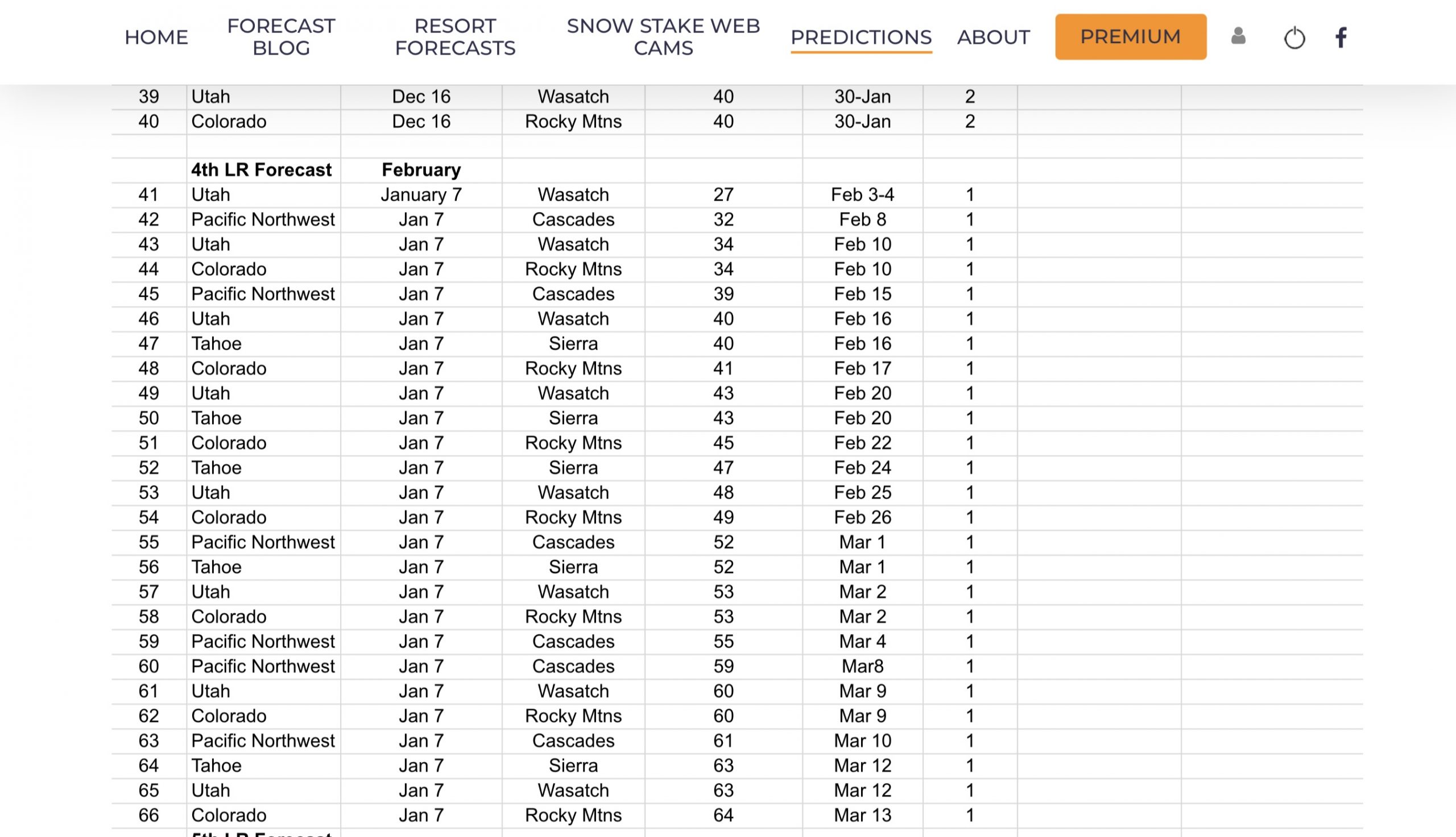
Long-Range Forecast Predictions thru March
 Forecasted Areas
Pacific Northwest Cascade Mountains
Crystal Mountain, Mount Hood Meadows, Timberline, 49 Degrees North, Bachelor, Mt Baker,
Lake Tahoe Sierra Mountains
Heavenly, Palisades Tahoe, Kirkwood, Dodge Ridge, Donner Ski Ranch
Utah Wasatch Mountains
Alta, Park City, Deer Valley, Brighton, Snowbird, Brian Head
Colorado Rocky Mountains
Aspen, Aspen Highlands, Snowmass, Vail, Beaver Creek, Winter Park, Keystone, Arapahoe Basin, Breckenridge, Copper Mountain, Powderhorn, Ski Cooper, Telluride, Crested Butte, Silverton, Wolf Creek, Eldora, Loveland
–
