Daily Snow Stake


Surface Chart

All Snow Chart

Snow Totals thru Feb 25th

Next System (click to animate)

Forecast Summary
Heavy snow in the southern Cascades this morning, as this system works its way Southeast, makes a U-Turn and moves through Utah and Colorado. The main energy is diving south of the Cottonwoods but will get some back side snow as the Low passes through, later today.
We have what is left-over from the cut-off system, that is dumping in southwest Colorado and is stretching northward to the i-70 resorts. The heaviest snow is located in the San Juans, as this cut-off system will add 1-3 feet today, thru tonight, for Telluride, Silverton and Wolf Creek with the sweet spot being Wolf Creek.
Forecast
Colorado


Today
The cut-off low will be working its way through this morning and early afternoon. The second wave wits around the same time the Low exits. We will see heavy snow in the San Juans as the combination of the two systems produces some amplification.
Major powder day tomorrow at Wolf Creek, Telluride and Silverton expected with likely 2 feet before the lifts open tomorrow at Wolf, and around a foot for Telluride and Silverton. That is on top of what they received last night. Silverton 10, Telluride 11, and Wolf Creek 6.
Temperatures today will be mixed depending on location. We start off with the central and northern Mountains. Temps in the mid 20’s today with strong winds 15-25 with 35 mph gusts.
Southern San Juan Mountain temperatures will be bitter cold, wind chills near 5 below with strong winds 15-25 with 40 mph gusts.
Resorts along the divide are in for a cold windy day. Strong winds 20-30 with 45 mph gusts. Wind chills in the negative digits to -10.
Tomorrow
Snow continues and I am expecting the central, northern and resorts along the divid to have much better numbers.
High temperatures tomorrow are pretty even across the board, around the upper teens to low 20’s, with the exception of the divide. For the divide, it will be super cold, with a high of around 2, and starting the day around -2. Loveland and A Basin will have moderate winds, between 15-20 with 30 mph gusts, but the wind chills will be nasty. Make sure you dress warm!
Thursday
The snow exits and temperatures will be in the mid to upper teens. Winds will calm down, but still blustery due to gusts in the mid 20’s.
Next System Sunday
Utah

Today
The big winner with this storm will be Brian Head, due to its southwestern Utah location. Their storm totals should be between 1-2 feet. I am expecting 6-12 today with another 2-4 tonight.
For the Salt Lake resorts, there will be some breaks in the snowfall today, as the system works through. As the Low passes and we reach the backside bands, I expect the snowfall to crank back up. There is not a lot of energy on the backside, but I still expect another 2-4, possibly 3-5 today for Alta, Brighton and Snowbird, with maybe 1-2 for Park City and Deer Valley.
Temperatures will be in the single digits today with a high around 10. Winds are moderate between 10-15 mph.
Tomorrow will be a bluebird day with temperatures in the upper teens and light winds.
Thank you for reading the blog, as always, if you have any questions, or need personalized info for trip forecasts, please email me at Mike@FutureSnow.co
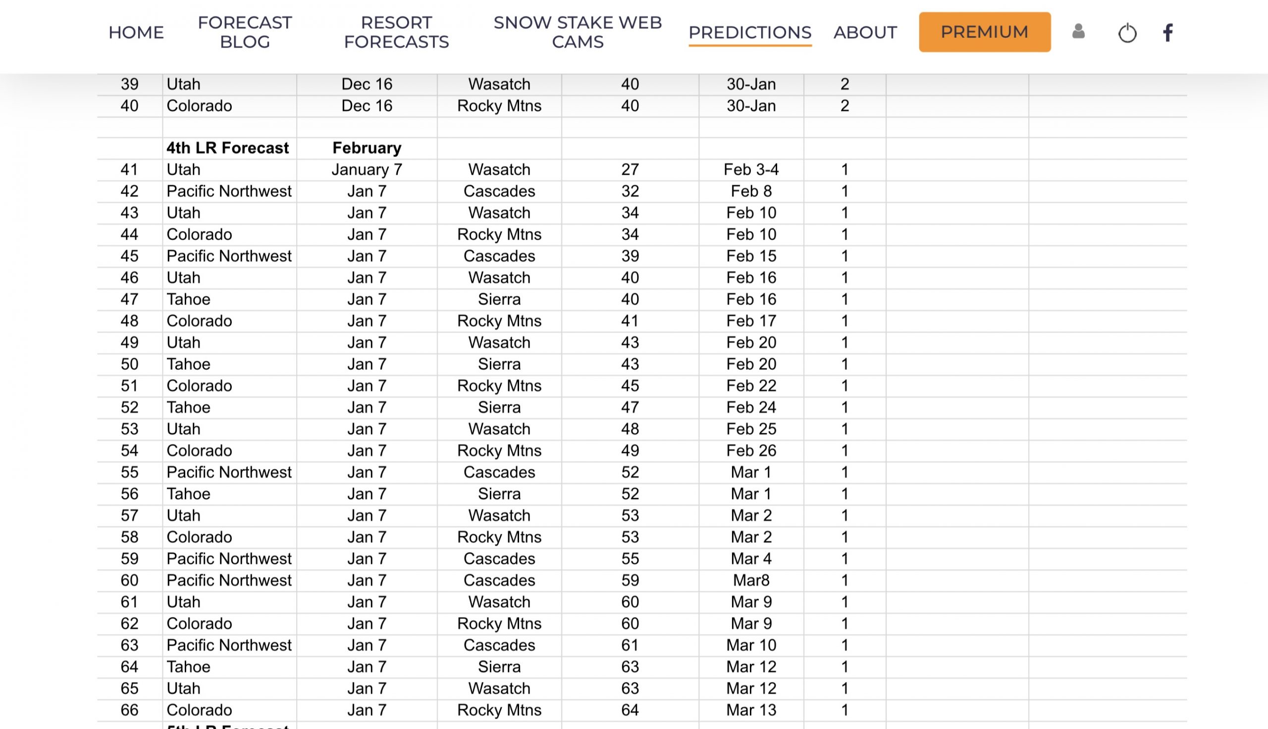
Long-Range Forecast Predictions thru March
 Forecasted Areas
Pacific Northwest Cascade Mountains
Crystal Mountain, Mount Hood Meadows, Timberline, 49 Degrees North, Bachelor, Mt Baker,
Lake Tahoe Sierra Mountains
Heavenly, Palisades Tahoe, Kirkwood, Dodge Ridge, Donner Ski Ranch
Utah Wasatch Mountains
Alta, Park City, Deer Valley, Brighton, Snowbird, Brian Head
Colorado Rocky Mountains
Aspen, Aspen Highlands, Snowmass, Vail, Beaver Creek, Winter Park, Keystone, Arapahoe Basin, Breckenridge, Copper Mountain, Powderhorn, Ski Cooper, Telluride, Crested Butte, Silverton, Wolf Creek, Eldora, Loveland
–
