Daily Snow Stake


Surface Chart

All Snow Chart

Pattern Discussion
The cut-off Low is spinning its way through Lake Tahoe. Those last three snow stake pics are Kirkwood, Alpine Meadows and Palisades Tahoe. It’s really hard to see, but it looks like 3 inches on the Kirkwood stake. The system should be out of the area by 10 o’clock, with maybe 1-2 more. We will take the snow; it’s been a few days since the last refresh.
The cut-off system dives deep into Baja California, before getting caught up in the flow Monday. it will reach Taos and Southern Colorado Monday night or early Tuesday morning.
The next system arrives in the Pacific Northwest Monday afternoon and is running a little early. The Madden Julian Oscillation (MJO) will be in phase 6 by the time the storm reaches the Cascades, so it will be interesting to see the totals. We do have some counter teleconnections working against the MJO. Both The AO (Artic Oscillation) and the NAO (North American Oscillation).


The positive AO and NAO are affecting the steering of the incoming systems. There is a high-pressure area that is blocking any potential of an Atmospheric River (AR) setup. I am working on a theory that the MJO boosts precipitation, which has been thought of before, but it is unknown in terms of where it fits in with the LRC (Lezak’s Recurring Cycle). We will see what the numbers are without the moisture tap, from an AR.
The benefit of the High-Pressure block should be cold air. Which is showing up on the temperature model run. Early indications are that snowfall totals for the Lake will be modest, under a foot. We will compare the totals with what happened last time through, to see what correlations we can make. If the snow totals are similar elsewhere, such as Utah and Colorado, then we have more positive data that would support the MJO connection.
Storm History
We had a strong storm come through at the end of January, that dumped double digit totals in Utah and Colorado. 3-day totals at Alta 23, Snowbird 23, Park City 15 and Brighton 33.
In Colorado, Beaver Creek 23, Vail 24, Steamboat 31 and Crested Butte 21.


Thank you for reading the blog, as always, if you have any questions, or need personalized info for trip forecasts, please email me at Mike@FutureSnow.co
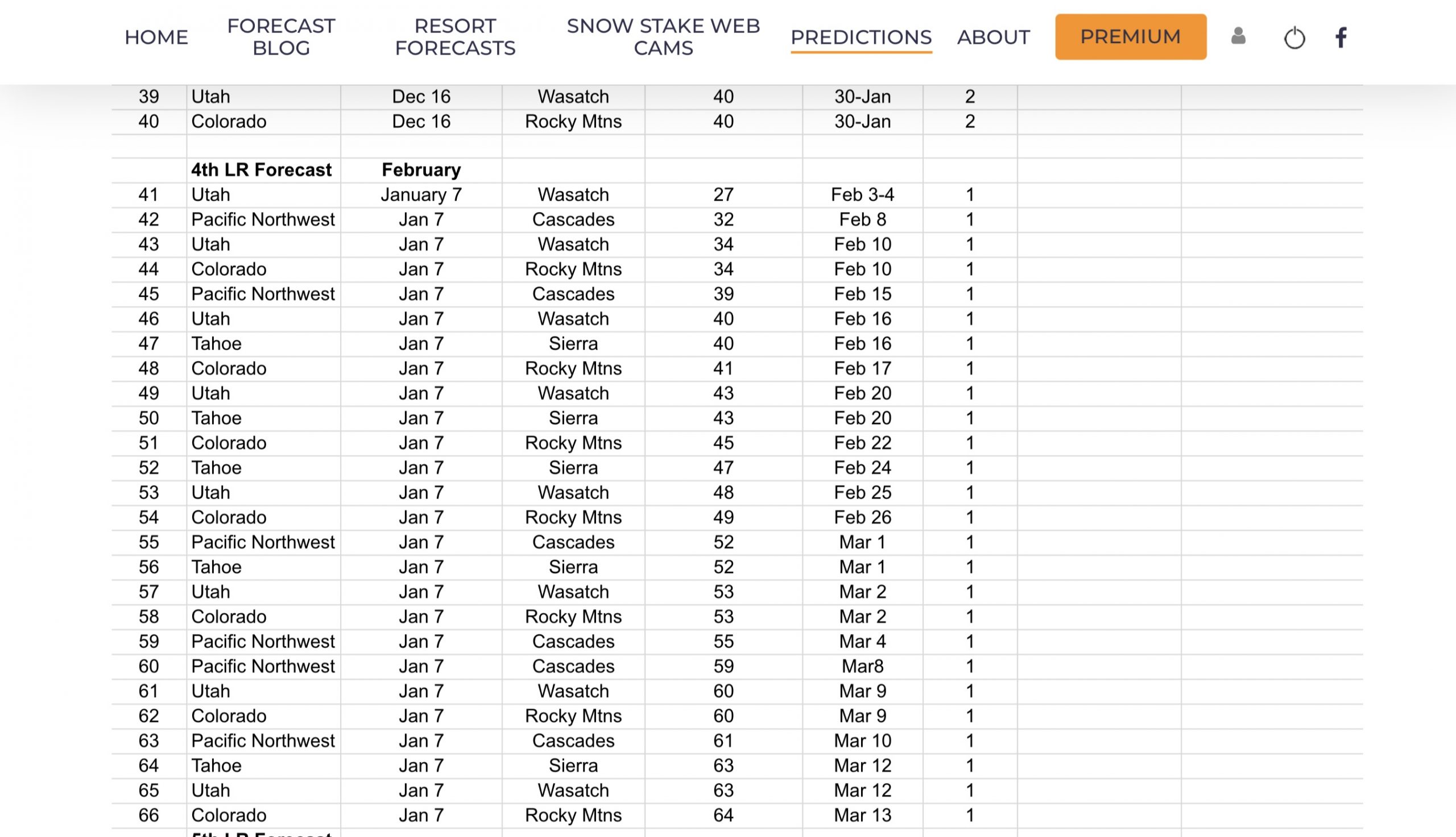
Long-Range Forecast Predictions thru March
 Forecasted Areas
Pacific Northwest Cascade Mountains
Crystal Mountain, Mount Hood Meadows, Timberline, 49 Degrees North, Bachelor, Mt Baker,
Lake Tahoe Sierra Mountains
Heavenly, Palisades Tahoe, Kirkwood, Dodge Ridge, Donner Ski Ranch
Utah Wasatch Mountains
Alta, Park City, Deer Valley, Brighton, Snowbird, Brian Head
Colorado Rocky Mountains
Aspen, Aspen Highlands, Snowmass, Vail, Beaver Creek, Winter Park, Keystone, Arapahoe Basin, Breckenridge, Copper Mountain, Powderhorn, Ski Cooper, Telluride, Crested Butte, Silverton, Wolf Creek, Eldora, Loveland
–
