
Hurricane Page (newest to oldest)
 This is a free service from FutureSnow.co. If you like to Ski or Snowboard, this is your site for weather inside information. We predict the weather months in advance so you can plan that perfect trip around powder.
Become a member today! Click on the Premium button above to subscribe.
Posts are in order of newest to oldest:
Posted July 8, 2024
 Corpus Christi Landfall
We are on day 6 of cycle 8 of this year’s LRC (Lezak’s Recurring Cycle), Hurricane Beryl made landfall last night at one of our target cities of Corpus Christi Texas. It came in just under the wire of our 5 day +/- time frame, hitting the Trifecta–date, path and location.
None of this would be possible without Gary Lezak’s discovery, 25 years ago, that the weather we experience is not random, but actually cycles and repeats. That is why so many of you who are passionate about skiing and snowboarding support this site. The world is beginning to wake up to our reality. I thank you from the bottom of my heart that I get to bring this technology to you. The endless search for powder.
This closes the chapter on the first set of predictions and begins the next.

Could we have another hurricane in Texas?
We have had a landfall in Texas and if you remember last year, Hurricane Hilary hit, then two cycles later, Hurricane Lidia threatened the same area. It is possible that we could have another hurricane hit Texas in upcoming cycles. The next potential pattern dates are August 16 and September 30.

Baja On the Clock
 Our attention now turns to the next possibility on the list, Baja California. Over the last 8, or so, model runs we have been seeing the potential for our Baja storm showing up in the predicted area. It is unlikely this time of year that the storm will take the correct path, due to the jet stream being so far north, but either way this is a strong indication for upcoming cycles, if it harmlessly drifts out to sea.
There is very warm water where the projected storm is showing up. The last few model runs have the storm on a heading towards Hawaii. It will have to survive the cooler waters to reach the islands.
Below is the current ENSO animation from the Climate Prediction Center. Click to animate.

Posted July 4, 2024
Happy 4th of July

Just a quick update on Hurricane Beryl. We are under 90 hours away from landfall in the Gulf of Mexico and the track continues to be around the targeted area.
The storm will take a severe hit when it passes the Yucon Peninsula, but most models have it reforming as it heads towards the coast. The best information on this storm is found at the National Hurricane Center and TropicalTidbits.com. You can find all of the model runs there if you want to geek out.


Posted July 2, 2024
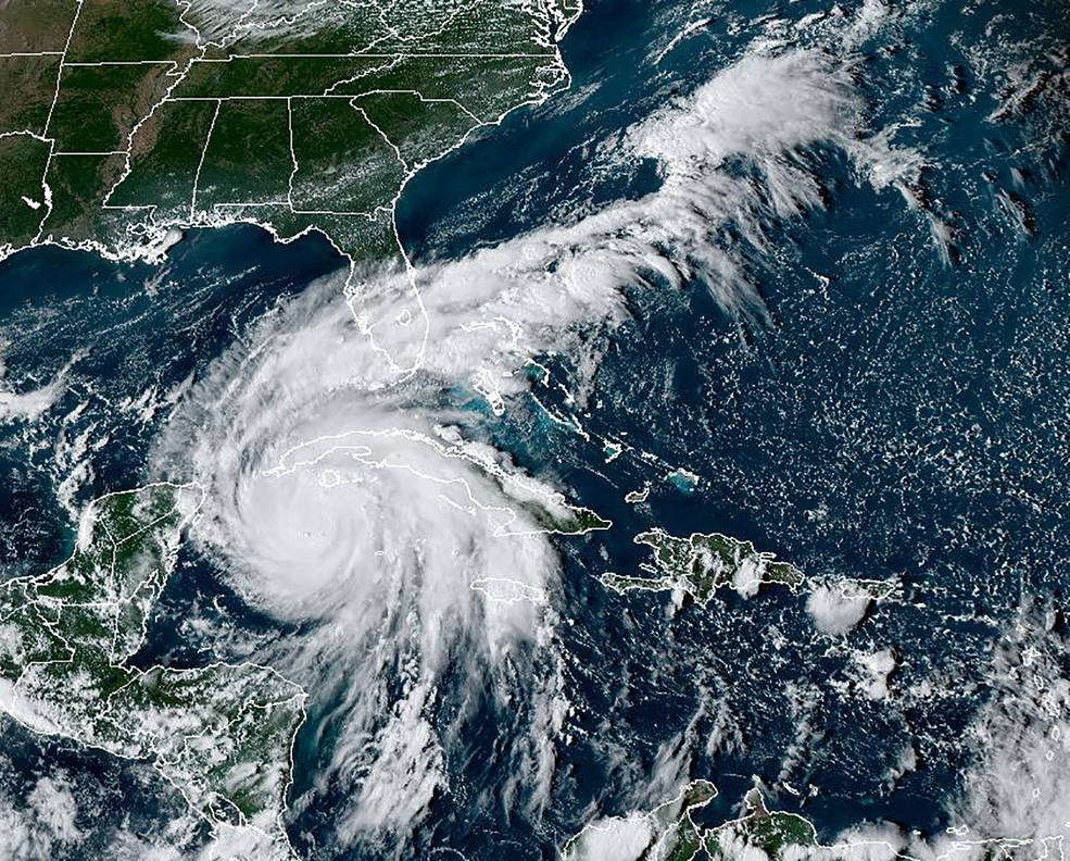
Hurricane Beryl

Above is the preferred track from my take on the LRC and the cycling pattern. This model run has it going thru the Yucon Peninsula towards Corpus Christi. The storm is quite strong and is expected to hit Jamaica tomorrow, as a category 3 or 4, with up to 150 mph winds, then weaken due to the topography of the island. The model solution takes the track thru the Yucon peninsula and then the storm is downgraded to a tropical storm.
The latest track makes landfall at Corpus Christi. It is still possible for a slight right turn to “thread the needle” between the Yucon peninsula and Cuba. Which was how it tracked in the fall. If that happens it will likely be a hurricane when it makes landfall in Texas. Below is the projected path of the storm from last year, along with tropical indicators illustrated from Weather 2020. These charts and indicators are how we predict hurricanes.


Latest Model Runs from GFS, HAFS A, HAFS B, HMON


Posted June 21, 2024
 Next Window

Hello everyone, I hope y’all are doing well. We are in the next phase of potential threats–albeit it is still really early in the season, but it is worth mentioning due to the hype machine (media) that keeps us “informed”.
Looking at the video board (above) from NBC, you can see the areas of potential development align with our forecast from May 19th for Brownsville and Florida. The storm that just came through Texas, Tropical Storm Alberto, and the heavy rains in Florida, are all from last fall’s pattern and are on schedule.
Looking at the spreadsheet chart of cycle dates, we are now entering the window that procured Hilary. Hilary hit last year off the west coast affecting San Diego, then an echo of Hilary, Lidia hit two cycles later.

We (FutureSnow) predicted Hilary based on Hurricane Estelle and Hurricane Kay, to the day, path and location. That hurricane developed in the preceding cycle pattern (22-23 49-day cycle).
There are certain windows, or parts of the pattern that are more conducive for hurricanes than others. We are entering one of those windows now, so we will look for parts of the pattern that align with those parameters.
Below are a couple of charts that came through last week, during the preceding hurricane window. The echo of Hurricane Lee shows the same setup that we had back on September 16th.
The following slide shows the current setup 6 cycles later, with a possible return next month July 27th for Maine/Nova Scotia and then September 9th. This specific hurricane has a less likely scenario that could occur 8 days earlier July 18 or Sept 1.
Look at these charts, they are practically identical.


Typhoon Prediction

This is the part of the pattern that produced a Typhoon last year (Typhoon Koinu) and it is showing up, on time, on the GFS. This will be a first if this happens, that I know of. I don’t think anyone has ever predicted a Typhoon with the date, location, and path, so we’ll see how we do.

Typhoon Koinu October 5, 2023
Looking at El Nino and steering winds.


June 3, 2024
FutureHurricanes.com 2024 Forecast

This graph above shows the average date range for hurricanes and tropical storms. When we look at the FutureHurricanes.com chart that follows below, you can keep this chart in mind and know that the most likely time for these storms to hit will be in between mid-August to mid-October.
Here is the list. Based on what happened last fall, we know the primary hotspots for hurricanes are the Florida coast (both east and west) and the Carolina’s. In the Pacific we have Puerto Vallarta on the west coast.
Secondary locations are Texas, near Corpus Christi, Baja California and Maine or the east coast of Nova Scotia.
The above locations saw storms last year and are probably part of last year’s pattern, however using the criteria that I used last year to predict Hurricane Hilary (Hurricane Kay the previous year), these locations are in play again this year.


Let’s dive a little deeper. Sure, those two hurricanes were strong indicators that a repeat would occur during the same date range 8 cycles later. But, in my analysis of hurricanes that have occurred over the last 10 years, these storms tend to occur between anchor points indicated below in red. Estelle doesn’t seem to fit, but that is due to the timing of the storm (mid-July) and the transition from the previous pattern.

Hawaii
We talked about Hawaii last year, as a possible hotspot for hurricanes due to Hurricane Calvin (July 11-15) the year before.
I did not predict that Hawaii would get a hurricane, because that would be like hitting a bullseye in darts, due to the small area of land mass in the middle of the ocean.
I did think that there would be storms in the Pacific due to El Nino and these indicators I was seeing below that were between anchor points teleconnection wise.


Dora ended up being catastrophic due to the huge area of high pressure to the northeast that amplified the winds from Dora.

FutureHurricanes.com
Official Predictions for 2024 (Thru October 1)
Hurricane Season is from June 1 to November 30
12 Storms, 6 Hurricanes, 2 Major
During an average hurricane season, there are 14 named storms, 7 hurricanes, and 3 major hurricanes. FutureHurricanes is predicting a slightly below average season, with 12 named storms, 6 Hurricanes and 2 Major Hurricanes.
I have to admit that I am a little worried about this prediction because the Atlantic basin is so warm. The LRC has been shown to be a solid predictor for the type of season we will have based on what occurred in the fall.
The fall was pretty quiet so that should mean that it should be quiet until the new pattern is in place by October. Was it that quiet because El Niño wasn’t in full effect yet? Time will tell.
Projected Paths
Below are the paths that the storms took last fall. Click to animate.
First example is the Puerta Vallarta path. In the second example, don’t watch Hurricane Hillary, watch the path that the disturbance in the Bahamas takes towards the Texas coast.
This storm could hit Florida, the Gulf coast or Texas. Finally, the last example is of Baha California.


Typhoon Prediction

This one is a little hard to see but keep an eye on the area where the arrow is pointing (not the huge storm by the Aleutians). The path of the storm will be similar to this storm from last year.
This storm should hit Taiwan and possibly make landfall in Hong Kong. June 29th, August 13, Sept 27th or November 10th.
Last Year’s Predictions

This is a screenshot of last year’s predictions made May 19th. You can find the original post either by searching the date of the post, or you can click the link Hurricane Forecast 2024 – FutureSnow
This link will take you to our Hurricane page that is in chronological order from most recent to oldest. The original post from May 19th is at the bottom.
Last year we accurately predicted 3 Hurricanes. Hilary, Idalia and Lidia.


Predictions are +/- 5 days from the listed date
April 19, 2024
I will go into more detail about the path of each of these possible storms in the next few weeks, but here is the early release that I sent to colleagues in an email dated March 8.

Posted October 10, 2023
Hurricane Lidia

It’s officially a hurricane, Lidia and that’s officially three hurricanes predicted by FutureSnow (FutureHurricanes.com). Who says you can’t predict hurricanes months in advance? Below are some charts and information from the National Hurricane Service. You can visit their website nhc.noaa.gov for more information.


This storm is taking a new track due, most likely because of the new cycling pattern, which began about October 6th. This most likely concludes the predictability of last year’s pattern, but sometimes there is a lag in between cycle years, so the return of Idalia (October 14-25th) and Lee October 28-14th are possible. You may notice a larger range than the May 19th predications, that is because of the new cycle length (still verifying).
Below are all of the storms so far. Followed by the predictions chart from May 19th.


Possible Hurricane Dates (prediction date May 19th)
Below are the updated predictions for possible hurricanes using our long-range prediction formula.
Aug 12-17 Pacific Storm—–Verified Hurricane Hilary
Aug 30-Sept 6 Florida—–Verified Hurricane Idalia
Sept 26-Oct 3 Florida (added Sept 4th)
Sept 27- Oct 5 Hawaii
Sept 30-Oct 3rd Yucatan
Sept 30-Oct 5 Pacific Storm
Oct 4-12 Possible Return of Hilary——Verified Hurricane Lidia
You can find the original post May 19th, and all Hurricane posts on this page—most recent posts appear first. https://futuresnow.co/hurricane-forecast-2023/
Posted October 5, 2023

Tropical Storm Lydia
We have a name, Lydia. This storm is a little disorganized, as the pattern is changing from last year to this year’s. This storm is going to wander for the next couple of days. There are a couple of other storms that are developing, below is the latest chart from the National Hurricane Center.
If Lydia becomes a Hurricane then that will be 3 Hurricanes predicted this year. All technically predicted on May 19th, but honestly I did not expect to get a “two for one” with Hilary and possibly Lydia. The cycling pattern is pretty amazing.

Posted September 29, 2023
Hurricane Watch
We continue to keep an eye on the tropics for any possible development. We’ve seen several things that look like they will develop, and then fall apart. I think it’s safe to say that hurricane Dora will not return.
Hilary, on the other hand, is now under a hurricane watch. The last couple Model runs have hurricane Hillary showing up right on time, with the correct path and location.

That is all the detail for now, as this is still really early, but I thought I would at least make a quick post on it due to it being in the right place at the right time.
Below is the updated hurricane prediction list.
Possible Hurricane Dates (prediction date May 19th)
Below are the updated predictions for possible hurricanes using our long-range prediction formula.
Aug 12-17 Pacific Storm—–Verified Hurricane Hilary
Return Date Oct 1-10
Aug 30-Sept 6 Florida—–Verified Hurricane Idalia
Return Date Range Oct 19-29
Sept 26-Oct 3 Florida (added Sept 4th)
Sept 27- Oct 5 Hawaii
Sept 30-Oct 3rd Yucatan
Sept 30-Oct 5 Pacific Storm
Thanks for reading the blog! If you have any questions, feel free to comment below or email me at Mike@FutureSnow.co
Posted September 21, 2023
 Hurricane Watch
We have been watching the models for the return of Dora, along with the predicted hurricanes for Florida and the Yucatan. There have been many solutions that have shown possible tracks that line up with these predictions. Hawaii appears to be the strongest candidate at the moment, however the storm in the Atlantic has been on the models but the track has been very inconsistent. There should be a better solution in the next couple of days.
 Possible Hurricane Dates (prediction date May 19th)
Below are the updated predictions for possible hurricanes using our long-range prediction formula.
Aug 12-17 Pacific Storm—–Verified Hurricane Hilary
Aug 30-Sept 6 Florida—–Verified Hurricane Idalia
Sept 26-Oct 3 Florida (added Sept 4th)
Sept 27- Oct 5 Hawaii
Sept 30-Oct 3rd Yucatan
Sept 30-Oct 5 Pacific Storm
Thanks for reading the blog! If you have any questions, feel free to comment below or email me at Mike@FutureSnow.co
Posted September 15, 2023
Hurricane Lee Update


Latest GFS Track (click to animate)


Hurricane Lee is related to Hurricane Fiona

This hurricane is related to Hurricane Fiona. Fiona occurred Sept 14-23rd during the first cycle. Hurricane Lee occurred, relatively during the same period in cycle 8. Looking at the path above on the chart from NOAA, you can see a similar path. There are always differences, due to trade winds, teleconnections, etc, but the path and makeup of these storms are usually similar.
How can we predict these months in advance? It’s because of the cycling pattern, the LRC. You can sign up for a 7-day trial and learn all about the LRC and our patent pending model for free. If you like to Ski or Snowboard, you have to have our technology to plan a trip.
As I have stated before, I did not list this storm on the Hurricane Prediction Chart, because its track would not be a threat to the tropics. Our partner, Gary Lezak and Weather 2020, did have this on their list. I talked about this storm on X last week stating that this storm will be similar in strength to the last time it came through (Fiona), last September. It looks to be very similar. These are pictures from the damage in Nova Scotia.

Possible Hurricane Dates (prediction date May 19th)
Below are the updated predictions for possible hurricanes using our long-range prediction formula.
Aug 12-17 Pacific Storm—–Verified Hurricane Hilary
Aug 30-Sept 6 Florida—–Verified Hurricane Idalia
Sept 26-Oct 3 Florida (added Sept 4th)
Sept 27- Oct 5 Hawaii
Sept 30-Oct 3rd Yucatan
Sept 30-Oct 5 Pacific Storm
Oct 4-12 Possible Return of Hilary
Thanks for reading the blog! If you have any questions, feel free to comment below or email me at Mike@FutureSnow.co
Posted September 12, 2023
Hurricane Lee
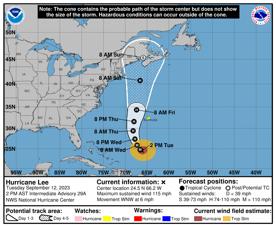
Here’s an updated path of Hurricane Lee. Does this hurricane path look familiar? It should, it is similar to Hurricane Fiona from last year.
Sorry in advance but, I’m going to be a little redundant with this post from the last post. But this is one of the most incredible examples of the Cycling Pattern, the LRC.
September 17- 22 last year, Hurricane Fiona took a track up the north eastern seaboard. One cycle later, Hurricane Nicole hit Florida. Seven cycles after Nicole, at almost the same time frame, we have Hurricane Lee. Does that mean that we will have a repeat of Hurricane Nicole between October 23-31? I would not bet against it. In fact, I am going to add that possibility to our updated list.


There are so many similarities between these two above charts of Fiona and Lee. We are still more than two days out before Lee is absorbed by the flow. I will do another post with the updated track tomorrow.
Posted September 9, 2023
Lee


 Well, here we go again with another Atlantic hurricane. Presently at Category 3 strength with max sustained winds at 115 mph. This storm is part of the cycling pattern, I did not list this one because of the track, but Gary with Weather 2020, who tracks all of the possible hurricanes, has this one on his list.
This storm is related to Hurricane Fiona from last year and it took a very similar track. Take a look.

So many similarities to Lee, it’s amazing. There is even a companion hurricane that pops up directly northeast, just like Fiona from last year. There are a couple of new features that are there that are a part of the new pattern–can you see anything different that will be a part of the new pattern?
New Pattern
There is a big storm that follows a small wave through northern Canada, that will likely take a northern track in October. This could be a big storm for Washington, Idaho, Montana and Wyoming, with a second cycle that should swing down to Colorado and may be a strong storm. It is soooo early, but something to watch.
Hurricane List
 Let’s take a look at the updated list (click to enlarge). You can scratch off Louisiana date, because the Florida path eliminates that prediction–this was an either-or situation, which we explained with our original forecast May 19th.
Louisiana is NOT off the hook yet. This storm could return next cycle and hit Louisiana October 14-22nd.
There is another Florida possibility on September 29th.
This is not on the list, but I think I should at least mention it. This is a small system that could pop up north of Cuba. The track is difficult to predict. I see two possibilities. A track that splits Cuba and Florida and hits the Gulf Coast (probably strengthen to a hurricane) or, flow up either side of Florida. The latter would probably just be a Tropical storm.
You can find the original post, and all Hurricane posts on this page—most recent posts first. https://futuresnow.co/hurricane-forecast-2023/
Hawaii is next in the list. That doesn’t mean there will be a long break between possible hurricanes, that simply means I did not see many recurring storms during this period. With the exception of a possible storm that could come thru Honduras or Nicaragua on Sept 17th. That could reach Hurricane strength, but probably a tropical storm at best.
Posted August 30, 2023
Idalia

 We are entering September on a high note, with our second consecutive prediction. I am watching coverage right now, hopefully everyone headed the warnings and moved to high ground.
 This storm will move northeast thru Georga and the Carolinas and meander out to sea, where it will redevelop and will likely take a U-turn and skirt the east coast before exiting near Maine.
Below are the 500 mb and MSLP surface chart with the track. It’s a little easier to see on the MSLP surface chart.


Patent Pending Weather 2020 Model
The Weather 2020 Model predicted rainfall totals that aligned with this storm, back on July 12th.

Again, I had the primary track from the east coast. I did mention, back on the original forecast May 19th, that I thought the secondary track (turned out to be the correct track) was unlikely. I should have paid attention to the model prediction and changed the path, but the model run was 4 weeks later. Two out of three (Date and Location) is still a huge success for our system.
With Hilary, we hit the Trifecta, Path, Date and Location. Those of you who have been around for a few years know that is an endearing term.
Let’s take a look at the updated list (click to enlarge). You can scratch off Louisiana date, because the Florida path, that eliminates that prediction–this was an either-or situation which we explained with our original forecast May 19th.
Louisiana is NOT off the hook yet. This storm could return next cycle and hit Louisiana October 14-22nd.
There is another Florida possibility on September 29th.
This is not on the list, but I think I should at least mention it. This is a small system that could pop up north of Cuba. The track is difficult to predict. I see two possibilities. A track that splits Cuba and Florida and hits the Gulf Coast (probably strengthen to a hurricane) or, flow up either side of Florida. The latter would probably just be a Tropical storm.
You can find the original post, and all Hurricane posts on this page—most recent posts first. https://futuresnow.co/hurricane-forecast-2023/
Hawaii is next in the list. That doesn’t mean there will be a long break between possible hurricanes, that simply means I did not see any recurring storms during this period.
Posted August 27, 2023

Idalia

We have a name, Idalia, but not yet a Hurricane. Once it is officially a hurricane, we will have correctly predicted two hurricanes in a row—WOW!
With Hilary, we hit the Trifecta, path, date and place. Those of you who have been around for a few years know that is an endearing term. With Idalia, we are going to get 2 out of 3. I did say that there was a possibility of a west coast impact, but I truly thought it would be east coast. The path was incorrect, but I’ll take it.
 Let’s take a look at the list (click to enlarge). You can scratch off Louisiana date, because with the likely Florida path, that eliminates that prediction–this was an either-or situation which we explained with our original forecast May 19th.
You can find that post, and all Hurricane posts on this page—most recent posts first. https://futuresnow.co/hurricane-forecast-2023/
Hawaii is next in the list. That doesn’t mean there will be a long break between possible hurricanes, that simply means I did not see any recurring storms during this period.
LRC (Lezak’s Recurring Cycle), Index Cycle (Jerome Namias)
The weather repeats, that is what the LRC is about. Those who say that “the weather has no memory”, or that mother nature is random, are simply wrong–they just can’t see it.
Jerome Namias discovered the cycling pattern back in the 40’s, then it got lost in time. Gary Lezak discovered the Pattern in the late 80’s and has spent his life perfecting this forecasting method. I followed Gary’s blog and started using the pattern over 10 years ago to plan ski trips.
It’s become an obsession.
Every day I pour through charts and spend hours working on crazy theories until they either prove to be valid, or wrong. Thousands of charts, hundreds of folders.


All for snow….and hurricanes.

Posted August 26, 2023
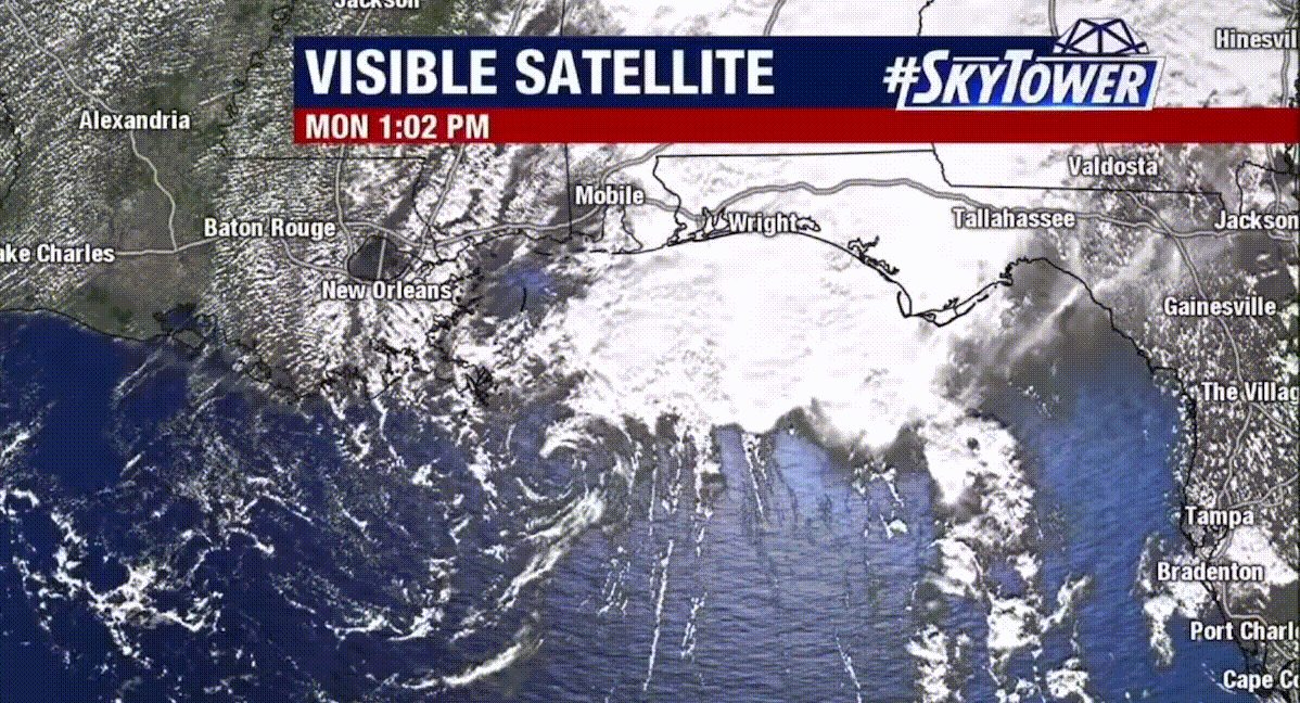
Below are a couple of recent model runs that show an uptick in Atlantic hurricane activity. The first chart is the most recent and most likely to develop into a tropical storm. This storm in the Gulf comes right up the gut, similar to Hurricane Marco August 24th, 2020.
The second chart is another possible solution from yesterday. Both possibilities will impact Florida during the predicted dates. It’s also possible that nothing will happen.


Below is Hurricane Marco, back in August 2020.
August 2020, Courtesy of Fox 13
We are still pretty early in the season and as you know, the early possibilities are hitting. That means that more are possible next cycle as well. When you look at the hurricane dates below, notice we added Hawaii.
We talked about Hawaii way back in May as a possible location for hurricanes this year. Now, I did not predict landfall, that would be like hitting the bullseye in the middle of the ocean, but with Dora just 500 miles south, the return could hit or come close again late September and the first week of October.
You may notice the larger date range, this is because the new cycling pattern (23-24 LRC) will be settling in by the return, along with the new cycle length. Will it be longer or shorter?

22-23 Pattern Still in Charge
I am seeing subtle changes in the pattern but last year’s LRC is still in charge. We are late into August and the transition is underway. We will have a completely new pattern in place by the first of October. The GIF below is the last 30 days of 500 mb charts, in 4 seconds.
El Nino

The snow will be flying soon!
Posted August 19, 2023
FutureHurricanes.Com is just for fun, my real job is snow. For the record, we predicted the date, location and path of the storm, right here, on May 19th. Here is the link https://futuresnow.co/hurricane-forecast-2023/

Hurricane Hilary will weaken as it reaches the cooler water near SanDiego. The cool water actually comes from the Alaskan Current that runs down the coast from the gulf of Alaska. That is why hurricanes are so rare on the west coast.

Projected Storm Totals
The exact opposite occurs on the East Coast, the warm water from the Gulf of Mexico and Caribbean flows north to the coast to Maine—the Gulf Stream Current.
Hurricane Hillary is just another amazing example of the cycling pattern, the LRC (Lezaks recurring cycle). Look at these next two charts. Even though the new pattern is developing as we speak, the old pattern still cycling through. First, the most recent (today), and then last cycle.


Do you see how similar these charts are? That little “asterisk” at the same meridian as the present chart where Hillary is located. You can’t make this s- – – – up!
The snow will be flying soon!
Posted May 19, 6:26 am MT 5:26 PT
Hurricane Ian
Hurricane Forecast
The LRC (Lezak’s Recurring Cycle) can be used to calculate storms during hurricane season, based on indications of what has occurred during the cycling pattern, since it evolved back in October. This fall’s hurricane season will have 3-4 landfall events, with a total of 7-9 hurricanes.
A reflection of last year’s Hurricane Ian and Nicole will likely hit Florida again, with also a Gulf of Mexico and a Pacific storm, hitting somewhere between central to northern Mexico, including the possibility as far north as San Diego, which rarely gets hurricanes. Below are the listed dates along with alternate dates, 1 cycle earlier in parenthesis.
Below are the forecasted dates, in parenthesis, the early possibility’s, 1 cycle earlier.
Florida August 30-September 6th (July 12-19th)
This storm will come through Cuba, Puerto Rico or both hitting the eastern coast of Florida. It will then move north Northeast through the Carolinas and farther up the east coast exiting around Maine.
Sept 6-7th Louisiana (low possibility)
This storm is kind of either/or situation. If the above storm doesn’t hit Florida, it could take an alternate path, south of Florida, to Louisiana. Florida (above storm) is the most likely location. There is a possibility of this storm originating in the Gulf and moving East hitting the West Coast of Florida, but that is unlikely.
Yucatan Peninsula South to Honduras Sept 30 to October 3rd
Watch out Cancun travelers. This storm will originate in the Caribbean Sea and move west.
Pacific Storm Sept 30 to October 5th (August 12-17th)
This storm will originate of the South American west coast and move north northwest, likely west of Baja California, turning northeast around San Diego.
Thanks for reading, as always, if you have any questions, please email me at Mike@FutureSnow.CO
Cycle Comparison 22-23 (3 Cycles)
The video moves at a slow pace, but even with the slow pace, it is hard to see everything on the screen, so use the slider to move at your own pace.
I am really proud of this video because first, it shows the fluctuation of the amplified pattern in each of the 3 cycles. Amplification occurs from a combination of teleconnection influences, such as, the Artic Oscillation, El Nino Southern Oscillation, Madden Julian Oscillation, and others. When these influences align the pattern is amplified.
Second, the storms are closely synchronized. Each frame advance is a quarter day. You can see how the storms in each cycle closely follow the same track with slightly different timing.
Finally, the amplification. You can see how much the size and scope of the storms change. Especially the California storms. The amplification drops the angle of the storms to a more linear flow into the Sierra.
Posted August 16, 2023

Hurricanes Rare in San Diego
Since 1850, a mere eight tropical cyclones have unleashed their gale-force winds upon San Diego. These include the San Diego Hurricane, in 1858, Emily in 1965; remnants of Hurricane Joanne in 1972; and what was left of Hurricane Kathleen in 1976.
Hurricane Nora (1997) was downgraded to a tropical storm, and Hurricane Kay (2022), which struck Baja California as a Cat 1 Hurricane. The aftermath Kay’s remnants traversed Southern California, unleashing floods and wind gusts of up to 100 mph (160 km/h) in certain regions.
In the majority of cases, the primary impact of these cyclones on California manifests as rainfall. Occasionally, this precipitation escalates to a point of severity, leading to floods and resultant damage.

This storm is forming right now, in the warm waters off the coast of South America. Pacific storms are more likely this year, due to the warm waters from El Niño. We have already seen Hawaii being directly impacted by Hurricane Dora, which we talked about the possibility of a storm, hitting Hawaii in our official Hurricane Forecast May 19th. The echo of Dora could return between September 27 and October 5th
Atlantic and Gulf of Mexico storms are less likely this year, due again to El Niño. El Niño affects the trade winds, somewhat blocking them in the aforementioned areas. Hurricanes are still possible though, and we have predicted a strong possibility for Florida, and the gulf coast near Louisiana, to be hit.
Posted June 3, 5:26 am MT 4:26 PT
Hurricane Forecast
Hurricane Ian
The LRC (Lezak’s Recurring Cycle) can be used to calculate storms during hurricane season, based on indications of what has occurred during the cycling pattern since it evolved back in October. This falls hurricane season will have 3-4 landfall events, with a total of 7-9 hurricanes.
Florida will likely be hit again, with also a Gulf of Mexico and a Pacific storm, hitting somewhere between central to northern Mexico, including the possibility of San Diego, which rarely gets hurricanes.
Florida August 30-September 6th
This storm will come through Cuba, Puerto Rico or both hitting the eastern coast of Florida. It will then move north Northeast through the Carolinas and farther up the east coast exiting around Maine.
Sept 6-7th Louisiana (low possibility)
This storm is kind of either/or situation. If the above storm doesn’t hit Florida, it could take an alternate path, south of Florida, to Louisiana. Florida (above storm) is the most likely location. There is a possibility of this storm originating in the Gulf and moving East hitting the West Coast of Florida, but that is unlikely.
Yucatan Peninsula South to Honduras Sept 30 to October 3rd
Watch out Cancun travelers. This storm will originate in the Caribbean Sea and move west.
Pacific Storm Sept 30 to October 5th (Possibly 1 cycle earlier, August 12-17th)
This storm will originate of the South American west coast and move north northwest, likely west of Baja California, turning northeast around San Diego.
Thanks for reading, as always, if you have any questions, please email me at Mike@FutureSnow.CO
Posted May 19, 6:26 am MT 5:26 PT
Hurricane Ian
Hurricane Forecast
The LRC (Lezak’s Recurring Cycle) can be used to calculate storms during hurricane season, based on indications of what has occurred during the cycling pattern, since it evolved back in October. This fall’s hurricane season will have 3-4 landfall events, with a total of 7-9 hurricanes.
A reflection of last year’s Hurricane Ian and Nicole will likely hit Florida again, with also a Gulf of Mexico and a Pacific storm, hitting somewhere between central to northern Mexico, including the possibility as far north as San Diego, which rarely gets hurricanes. Below are the listed dates along with alternate dates, 1 cycle earlier in parenthesis.
Florida August 30-September 6th (July 12-19th)
This storm will come through Cuba, Puerto Rico or both hitting the eastern coast of Florida. It will then move north Northeast through the Carolinas and farther up the east coast exiting around Maine.
Sept 6-7th Louisiana (low possibility)
This storm is kind of either/or situation. If the above storm doesn’t hit Florida, it could take an alternate path, south of Florida, to Louisiana. Florida (above storm) is the most likely location. There is a possibility of this storm originating in the Gulf and moving East hitting the West Coast of Florida, but that is unlikely.
Yucatan Peninsula South to Honduras Sept 30 to October 3rd
Watch out Cancun travelers. This storm will originate in the Caribbean Sea and move west.
Pacific Storm Sept 30 to October 5th (August 12-17th)
This storm will originate of the South American west coast and move north northwest, likely west of Baja California, turning northeast around San Diego.
Thanks for reading, as always, if you have any questions, please email me at Mike@FutureSnow.CO
