Posted June 11, 2024
This is a free service from FutureSnow.co using the LRC (Lezaks Recurring Cycle). These are my own thoughts on how the pattern will play out this season, based on my interpretation of the pattern. If you ski or snowboard, the LRC is a great forecasting tool to plan a trip, weeks in advance, around storms to find the perfect powder trip for just 3.49 per month or $25 per year.
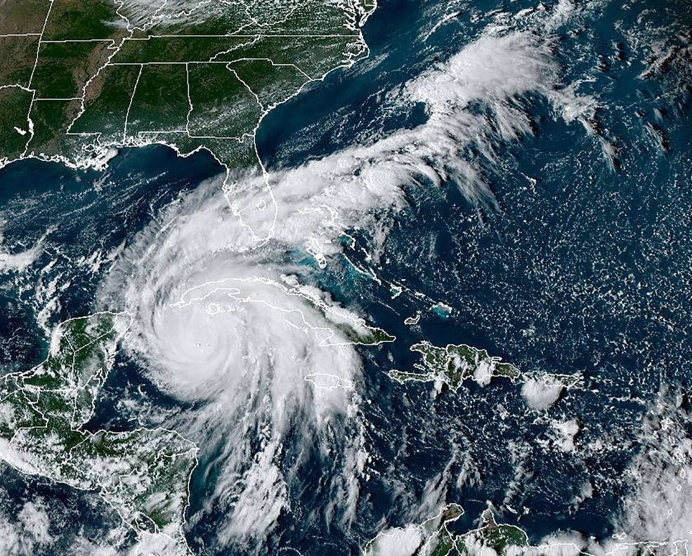
FutureHurricanes.com 2024 Forecast

This graph above shows the average date range for hurricanes and tropical storms. When we look at the FutureHurricanes.com chart that follows below, you can keep this chart in mind and know that the most likely time for these storms to hit will be in between mid-August to mid-October.
Here is the list. Based on what happened last fall, we know the primary hotspots for hurricanes are the Florida coast (both east and west) and the Carolina’s. In the Pacific we have pubertal Vallarta on the west coast.
Secondary locations are Texas, near Corpus Christi, Baja California and Maine or the east coast of Nova Scotia.
The above locations saw storms last year and are probably part of last year’s pattern, however using the criteria that I used last year to predict Hurricane Hilary (Hurricane Kay the previous year), these locations are in play again this year.


Let’s dive a little deeper. Sure, those two hurricanes were strong indicators that a repeat would occur during the same date range 8 cycles later. But, in my analysis of hurricanes that have occurred over the last 10 years, these storms tend to occur between anchor points indicated below in red. Estelle doesn’t seem to fit, but that is due to the timing of the storm (mid-July) and the transition from the previous pattern.

Hawaii
We talked about Hawaii last year, as a possible hotspot for hurricanes due to Hurricane Calvin (July 11-15) the year before. I did not predict that Hawaii would get a hurricane, because that would be like hitting a bullseye in darts, due to the small area of land mass in the middle of the ocean. I did think that there would be storms in the Pacific due to El Nino and these indicators I was seeing below that were between anchor points teleconnection wise.


Dora ended up being catastrophic due to the huge area of high pressure to the northeast that amplified the winds from Dora.

FutureHurricanes Official Prediction for 2024
12 Storms, 6 Hurricanes, 2 Major
During an average hurricane season, there are 14 named storms, 7 hurricanes, and 3 major hurricanes. FutureHurricanes is predicting a slightly below average season, with 12 named storms, 6 Hurricanes and 2 Major Hurricanes.
I have to admit that I am a little worried about this prediction because the Atlantic basin is so warm. The LRC has been shown to be a solid predictor for the type of season we will have based on what occurred in the fall.
The fall was pretty quiet so that should mean that it should be quiet until the new pattern is in place by October. Was it that quiet because El Niño wasn’t in full effect yet? Time will tell.
Projected Paths
Below are the paths that the storms took last fall. Click to animate.
First example is the Puerta Vallarta path. In the second example, don’t watch Hurricane Hillary, watch the path that the disturbance in the Bahamas takes towards the Texas coast. This storm could hit Florida, the Gulf coast or Texas. Finally, the last example is of Baha California.


Typhoon Prediction

This one is a little hard to see but keep an eye on the area where the arrow is pointing (not the huge storm by the Aleutians). The path of the storm will be similar to this storm from last year. This storm should hit Taiwan and possibly make landfall in Hong Kong. June 29th, August 13, Sept 27th or November 10th.
Last Year’s Predictions

This is a screenshot of last year’s predictions made May 19th. You can find the original post either by searching the date of the post, or you can click the link Hurricane Forecast 2024 – FutureSnow
This link will take you to our Hurricane page that is in chronological order from most recent to oldest. The original post from May 19th is at the bottom.
Last year we accurately predicted 3 Hurricanes. Hilary, Idalia and Lidia.


Predictions are +/- 5 days from the listed date

2023 Hurricane Forecast
Hurricane Ian
Hurricane Forecast
The LRC (Lezak’s Recurring Cycle) can be used to calculate storms during hurricane season, based on indications of what has occurred during the cycling pattern, since it evolved back in October. This fall’s hurricane season will have 3-4 landfall events, with a total of 7-9 hurricanes.
A reflection of last year’s Hurricane Ian and Nicole will likely hit Florida again, with also a Gulf of Mexico and a Pacific storm, hitting somewhere between central to northern Mexico, including the possibility as far north as San Diego, which rarely gets hurricanes. Below are the listed dates along with alternate dates, 1 cycle earlier in parenthesis.
Florida August 30-September 6th (July 12-19th)
This storm will come through Cuba, Puerto Rico or both hitting the eastern coast of Florida. It will then move north Northeast through the Carolinas and farther up the east coast exiting around Maine.
Sept 6-7th Louisiana (low possibility)
This storm is kind of either/or situation. If the above storm doesn’t hit Florida, it could take an alternate path, south of Florida, to Louisiana. Florida (above storm) is the most likely location. There is a possibility of this storm originating in the Gulf and moving East hitting the West Coast of Florida, but that is unlikely.
Yucatan Peninsula South to Honduras Sept 30 to October 3rd
Watch out Cancun travelers. This storm will originate in the Caribbean Sea and move west.
Pacific Storm Sept 30 to October 5th (August 12-17th)
This storm will originate of the South American west coast and move north northwest, likely west of Baja California, turning northeast around San Diego.
Thanks for reading, as always, if you have any questions, please email me at Mike@FutureSnow.CO
Cycle Comparison 22-23 (3 Cycles)
The video moves at a slow pace, but even with the slow pace, it is hard to see everything on the screen, so use the slider to move at your own pace.
I am really proud of this video because first, it shows the fluctuation of the amplified pattern in each of the 3 cycles. Amplification occurs from a combination of teleconnection influences, such as, the Artic Oscillation, El Nino Southern Oscillation, Madden Julian Oscillation, and others. When these influences align the pattern is amplified.
Second, the storms are closely synchronized. Each frame advance is a quarter day. You can see how the storms in each cycle closely follow the same track with slightly different timing.
Finally, the amplification. You can see how much the size and scope of the storms change. Especially the California storms. The amplification drops the angle of the storms to a more linear flow into the Sierra.
Open Resorts
California
Palisades
Utah
Snowbird, Solitude, Brighton
Colorado
Arapahoe Basin, Winter Park
Forecasted Areas
Pacific Northwest Cascade Mountains
Crystal Mountain, Mount Hood Meadows, Timberline, 49 Degrees North, Bachelor, Mt Baker,
Lake Tahoe Sierra Mountains
Heavenly, Palisades Tahoe, Kirkwood, Dodge Ridge, Donner Ski Ranch
Utah Wasatch Mountains
Alta, Park City, Deer Valley, Brighton, Snowbird, Brian Head
Colorado Rocky Mountains
Aspen, Aspen Highlands, Snowmass, Vail, Beaver Creek, Winter Park, Keystone, Arapahoe Basin, Breckenridge, Copper Mountain, Powderhorn, Ski Cooper, Telluride, Crested Butte, Silverton, Wolf Creek, Eldora, Loveland
–
