Daily Snow Stakes


 Surface Chart

GFS All Snow

Pattern Discussion
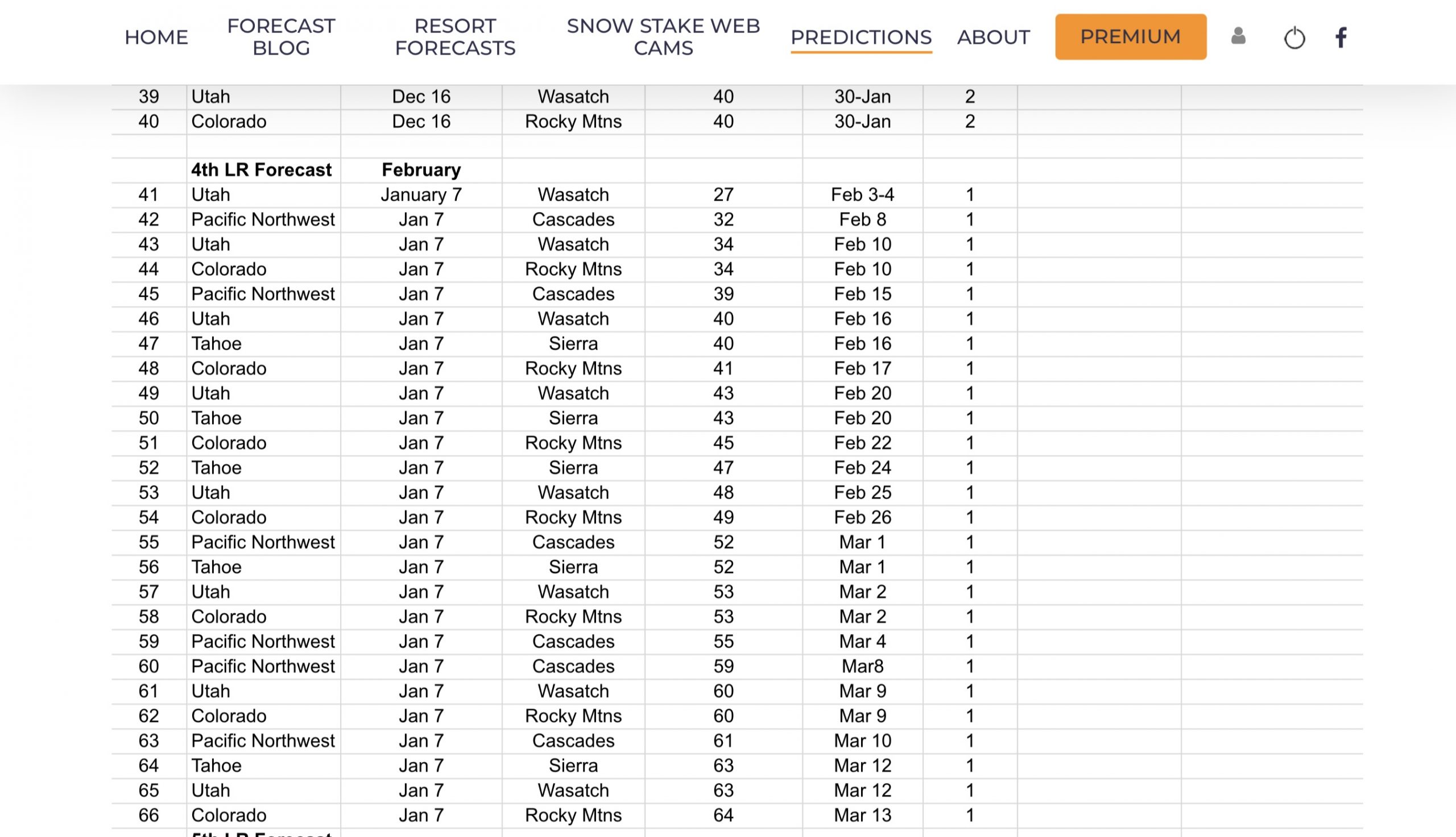
We have a break in the action as we are going through a lull, that has occurred in each of the last two cycles. The long-range forecast chart shows this gap, as we move into the next phase–the fourth long-range forecast, made on January 7th. We are presently nearly perfect, 39 out of 40, with only one bust, which is stupidly accurate. We have a variance of 2 days, due to uncertainty of the actual cycle length. That has made predictions easier, but that is still an incredible number. Moving forward, we will have a 1-day variance, so hopefully we have the cycle length dialed in correctly. The length does speed up and slow down, but 1 day is a pretty good number.
Teleconnections
We continue to monitor the teleconnection signals for clues to the strength of upcoming storms, beginning with storm 41. We want like both the Artic Oscillation and the North Atlantic Oscillation to be deep negative. Presently, they are both positive and are projected to remain positive. So, for the near term, the systems will be weaker than previous cycles.


The Madden Jullian Oscillation (MJO) is presently in phase 3 and trending in the right direction. We want the MJO to be in phases 6,7 and 8 to enhance storm strength. There is a strong indication that the MJO is enhancing this year’s systems, as well as last year’s cycle 3. We will get a better grasp on this correlation, as we enter the aforementioned phases, to see if we continue to see better numbers.

The next storm on the long range is 41 and is presently weak at the moment. It’s there, right on schedule, but weak. We have about 80 hours before it arrives for model improvement.
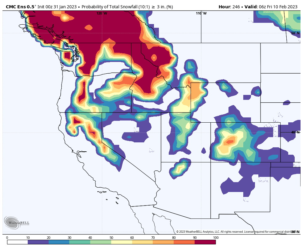
Looking at storm predictions 42, 43, and 44 (PNW, Utah, Colorado) are presently weak to moderate. The following map shows the projected totals for the next 10 days from the Canadian model. We have some strong numbers in the Pacific Northwest and into Canada.

Here is another cool map that is useful for chasing powder. This map is “probability of snowfall over 3 inches”, again from the Canadian model. The map is followed by a 12-inch map and finally a 24-inch map. They have maps up to 48 inches, I will have to remember these maps the next time we have a massive storm–perhaps storm 47 at Tahoe, February 16th.
These model maps are helpful for picking a target area to chase. Many of you know Powder Chaser Steve, from his blog at PowderChasers, or OpenSnow.com This is one of the tools in the toolbox for planning those trips.


Weather Bell is one of the tools we use for forecasting. You can click on the link and sign up and get seven days for free. It is really a cool site to look through, if you want to geek out looking at their cool weather products. Another cool site is Tropical Tidbits. This is a free site, but you are welcome to donate. I do donate to this site, because I use their maps and also enjoy the passion that the author, Dr. Levi Cowan has for tropical storms.
We will be launching FutureHurricanes.com this spring, to continue our passion for predicting hurricanes. This will be a free site with not many bells and whistles. It is mainly a place to document our predictions and thoughts about the upcoming hurricane season.
Thank You!
I want to thank you again, for subscribing to FutureSnow. I had no idea that I would create this place for long-range forecasting. The idea came from Gary Lezak, years ago. Many of you know that I tried to get Joel Gratz, founder of OpenSnow to use the theory. It took him a little too long to come around, so I just started it on my own. It has been so much fun delivering this to you, and I hope we continue to grow together. Please tell all of your ski/snowboard buddies about us! As always, if you have any questions, or need personalized info for trip forecasts, please email me at Mike@FutureSnow.co
Long-Range Forecast Predictions thru March
 Forecasted Areas
Pacific Northwest Cascade Mountains
Crystal Mountain, Mount Hood Meadows, Timberline, 49 Degrees North, Bachelor, Mt Baker,
Lake Tahoe Sierra Mountains
Heavenly, Palisades Tahoe, Kirkwood, Dodge Ridge, Donner Ski Ranch
Utah Wasatch Mountains
Alta, Park City, Deer Valley, Brighton, Snowbird, Brian Head
Colorado Rocky Mountains
Aspen, Aspen Highlands, Snowmass, Vail, Beaver Creek, Winter Park, Keystone, Arapahoe Basin, Breckenridge, Copper Mountain, Powderhorn, Ski Cooper, Telluride, Crested Butte, Silverton, Wolf Creek, Eldora, Loveland
–

I do think your accuracy is truly remarkable and I greatly enjoy/appreciate what you are providing, I am happy to subscribe. I also appreciate your openness with regard to calculating and reporting your accuracy. I wondered if you are also looking at accuracy in terms of notable snowfalls that occur that you had not predicted? Thank you and keep up the great work!
Hello TomGos, Thanks! To answer your question, we do. We track snowfall for 56 resorts. There are certain resorts, in a given year, that are harder to predict than others. Lake Tahoe is a great example. For our methodology, we must have these repeating storms occur in two cycles (that can include precycles). Tahoe is one of the resorts that storms hit in one cycle and not in another. We think we are on to “why” this happens, hinting on our MJO discussion today, but need more data. Now that we are in cycle 3, we are adding more storms for the Lake.
I received an email from NLTCrow with a similar question. He wrote, “Neither of our 2 big 3-5 foot storms this year on Nov 8 and Dec 10-11 were on your predictions list. As a skier yourself, you’ve gotta agree that missing both these 2 whoppers is way worse than making a 6 inch prediction that fails. And the 2 storms that are on there for this month have pretty much fizzled”. He’s absolutely right, we have to get better at predicting those storms. Tahoe is hard to predict, due to what are seemingly wildcard storms, that are usually linked to AR’s and MJO strength.
I have been thinking on how to do this, and what I’ve come up with is a possible solution. We could predict storms that occur in 1 cycle as a possibility–like a 70% chance. It is similar to how we forecast hurricane percentages. If a hurricane signature occurs in 4-5 cycles, there is an 80% chance it will occur. Something like that.
Great question, I think I’ll dive into this for tomorrows blog.
I found your site from opensnow the flakes podcast. I was skeptical at first, but your predictions just kept coming through. I’m planning a trip to Alta the first or second week of March, which would be the better week to go?
Hello Jackson t, I was just like you, years ago when Gary Lezak would talk about the repeating pattern. It’s hard to believe that in the 21st century, science hasn’t figured this out, and, when most meteorologists are presented with evidence of the repeating pattern, they still don’t believe it. Oh well, they will come around someday.
Ok, to your question. The first week is a partial week with March 1st on a Wednesday, there are a couple of storms that hit this week, but they only hit in 1 cycle. The second week is a better week to go, with a good storm that produced in the last two cycles, 31″ in cycle 2 and 51″ in cycle 3. Good luck, and let me know how it goes!