Daily Snow Stakes


Storm Total, (not cleared)
Surface Chart

GFS Surface Chart

Pattern Discussion


Lake Tahoe got in on the action yesterday, as at least 8 inches fell at Heavenly, from their webcam. Kirkwood’s webcam is off, it is still showing the last storm (Jan 14th). It has been 10 days since Tahoe’s last snow. Those are the only two that I know of, I wish every resort had a snow stake cam. It is so helpful to not only see who gets powder, but also the type of snow. Is it dry, wet, fluffy or wild snow? All good things to know.
Last cycle, we had higher snow totals at the Lake likely due to two things, first, an atmospheric river, second, the influence of the Madden Jullian Oscillation (MJO). This time thru, the MJO is in the wrong phase to influence so no AR effect. Also, the MJO is not in a phase that is helpful for enhancement. The other teleconnections are also different. The AO (Arctic Oscillation) is flipped to positive, from last cycle, so in the North Atlantic Oscillation (NAO). It will be interesting to see what these connections do in cycle 4.
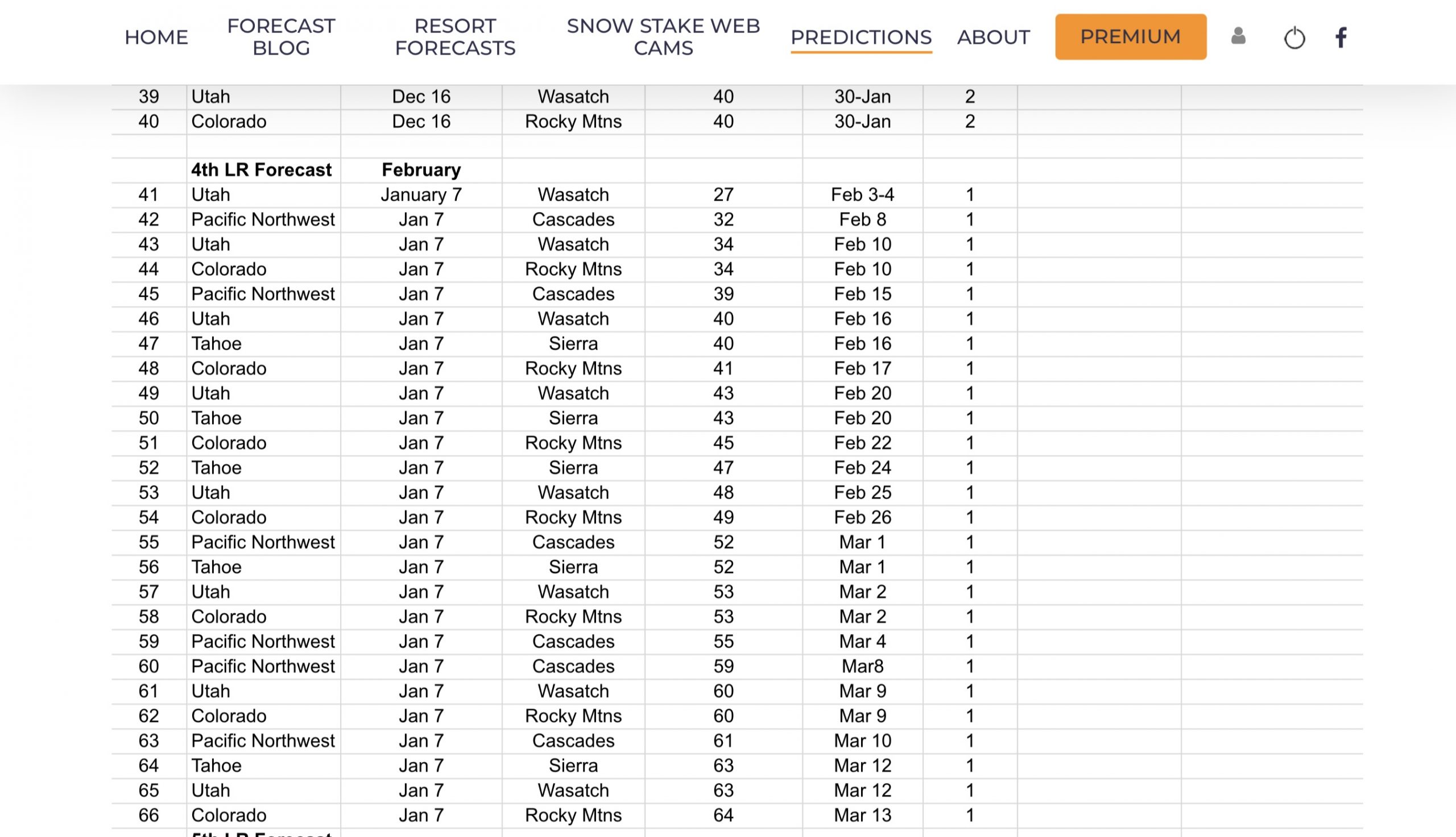
Back to ARs. ARs repeat, we discovered that last year. In cycles 2 and 3 of last year, there were 22 ARs, with 7 repeats, in the same place and 3 on the same date, different place. Just under half of the ARs returned on the same date. This year, there have been 19 ARs, with 5 repeaters. There is enough evidence for me to forecast an AR on February 28 (Gulf of Alaska) and March 10-11th (Tahoe or BC). If the MJO is in the proper phase 5,6, or 7, it will be Lake Tahoe. The hard part is waiting.
Forecast
Colorado

Today
Snow continues today for all of Colorado. Temperatures will be in the mid to upper 20’s with moderate to strong winds depending on the location. For areas along the divide, especially the passes will have the strongest winds with 50 mph gusts, so that could affect upper mountain lifts.
The models are a little more bullish, in terms of snowfall totals, for the resorts along the divide, Wolf Creek and Powderhorn, so I have upped the totals. This system moves out by this evening.

Next storm chance will be Saturday.
Thank you for reading the blog, as always, if you have any questions, or need personalized info for trip forecasts, please email me at Mike@FutureSnow.co
Long-Range Forecast Predictions thru March
 Forecasted Areas
Pacific Northwest Cascade Mountains
Crystal Mountain, Mount Hood Meadows, Timberline, 49 Degrees North, Bachelor, Mt Baker,
Lake Tahoe Sierra Mountains
Heavenly, Palisades Tahoe, Kirkwood, Dodge Ridge, Donner Ski Ranch
Utah Wasatch Mountains
Alta, Park City, Deer Valley, Brighton, Snowbird, Brian Head
Colorado Rocky Mountains
Aspen, Aspen Highlands, Snowmass, Vail, Beaver Creek, Winter Park, Keystone, Arapahoe Basin, Breckenridge, Copper Mountain, Powderhorn, Ski Cooper, Telluride, Crested Butte, Silverton, Wolf Creek, Eldora, Loveland
–
