


Is this fun or what?
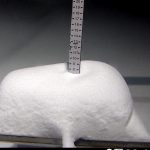
It’s been a long time since I have seen the widespread, deep snowfall, that we have seen in back-to-back cycles. The next round is under way and Whistler Blackcomb already has 11″ on today’s snow stake. The snow continues to pile up for the Pacific Northwest (PNW) today with another 3-5 before the storm exits Washington. Crystal Mountains snow stake is above showing 15! Timberline 13. Wow, what a good day to be in the PNW.
Oregon keeps on rolling with heavy snowfall today thru Thursday as the storm dives south and arrives in the Sierra by Thursday.

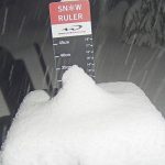
5 Day Total for Lake Tahoe
Finally, Lake Tahoe is Back! With heavy snow tonight, beginning around 10 pm. It has been 18 Days since the last snowfall back on November 13th. The energy from today’s system will be reenforced by second Low Pressure that follows Friday night, The Lake looks like it will be in the 2-3 feet range by the end of the day Saturday. Above is the 5-day total.
First Storm of Long-Range Chart

The storm Saturday is the first on the Long-Range Forecast chart. It is arriving 2-days early. You might notice that we have 2 days on the Forecast chart instead of the usual 1-day variance. That is because we have gone back and forth on the cycle length, and it appears to be on the shorter side, by a day and a half. We will dial this in by the release of our Christmas forecast.
Forecast
 PNW
PNW

Washington
Winter Storm Warning continues for the northern Cascades through 4 pm today. The storm will exit in late afternoon, but I expect a few lingering showers overnight. Expect 3-5 today with an additional 1-3 tonight. Light winds and cold wind chills in the single digits. 
Oregon

Winter Storm Warning continues through 10 pm tonight. Heavy snow today with highs in the mid to upper 20’s. Strong winds with gusts in the 50-mph range but will decrease to 10-20 mph as the storm moves to the southeast. Mt Hood will be in the 6-12 range today with Mt Bachelor around 4-8. Tonight, expect another 3-5 for both resorts.
Thursday
Snow continues with moderate winds with gusts in the low 20’s. The storm looks to exit in the early afternoon, but not after another 4-8 for Mt Hood Meadows and slightly less for Mt Bachelor.
Tahoe

Winter Storm Warnings begins at 10 pm tonight and runs through Thursday evening. Expect 4-8 overnight tonight, although there could be heavier amounts, Tahoe is tricky to forecast for.
Thursday
The heaviest precipitation will be during the day Thursday. I am expecting between 12-15 on the low side and 18-24 on the high side for Palisades, and Kirkwood, with slightly less for Heavenly.
Temperatures will be falling throughout the day and settle in the low 20’s by late in the day. The usual strong winds with gusts in the 60’s in the valleys and mountain top winds encroaching 100 mph. The low temps will help with the snow water content, with wetter snow in the beginning and dryer snow on top. We are looking at pretty even snowfall for most of the resorts with the bullseye hitting resorts along the crest, the aforementioned Palisades, Kirkwood and Heavenly.
The storm exits Thursday night, expect bluebird skies on Friday with temperatures in the low 30’s.
Thursday Night
Utah

Colorado

Long-Range Forecast thru December 21st

Subscription service begins in December.
 Forecasted Areas
Pacific Northwest Cascade Mountains
Crystal Mountain, Mount Hood Meadows, Timberline, 49 Degrees North, Bachelor, Mt Baker,
Lake Tahoe Sierra Mountains
Heavenly, Palisades Tahoe, Kirkwood, Dodge Ridge, Donner Ski Ranch
Utah Wasatch Mountains
Alta, Park City, Deer Valley, Brighton, Snowbird, Brian Head
Colorado Rocky Mountains
Aspen, Aspen Highlands, Snowmass, Vail, Beaver Creek, Winter Park, Keystone, Arapahoe Basin, Breckenridge, Copper Mountain, Powderhorn, Ski Cooper, Telluride, Crested Butte, Silverton, Wolf Creek, Eldora, Loveland

Thanks! What does the teleconnection data say in regards to the storms on the 10th & 18th for Colorado?
Looking good with the AO. The MJO is neutral. We might get some help from the PNA–its currently negative at .5. If it dives deeper that will strengthen the pattern as well.