Posted June 2, 5:26 am MT 4:26 PT


Welcome to June
 A-Basin picked up a couple inches this morning as we had cold enough air for June snow. The Montezuma Bowl camera shows heavy snow as of this post. This is the last weekend for A-Basin with the usual 2 lifts open, Black Mountain Express and Lenawee Express, but with 9 runs open, instead of the usual single run–white ribbon of death (WROD).
There will be cold enough air tonight for this to happen all over again tomorrow.
Meteorological Winter in the Southern Hemisphere


Its meteorological winter in the southern hemisphere and officially winter in another 19 days. This time of year, I am poring through charts and working on closing out the year. What a year it has been–record breaking, take that global warming!
Below are a few of screenshots of just a small portion of charts that I collect throughout the year. The first chart is 500mb charts, four for each day. The second chart is 500 mb charts tracking the cycle length over the years, dating back to 2012. The third chart if the northern hemisphere 500 mb.
Every day I record each MSLP, 500 mb and hemisphere charts in files that look like the first and third chart on my iPad. Thats about 4,400 charts a year, before any other pics, but are so helpful in analyzing the cycling weather pattern.


Also, I am looking at the southern hemispheres (SH) pattern. The two patterns are interconnected. There is a pretty good storm that is hitting this weekend for Patagonia ski resorts. I will be tracking the storms to discover the SH cycle length. That will give us clues for this coming winter. Enjoy the last weekend at ABay.

Click to Animate
Hurricane Forecast
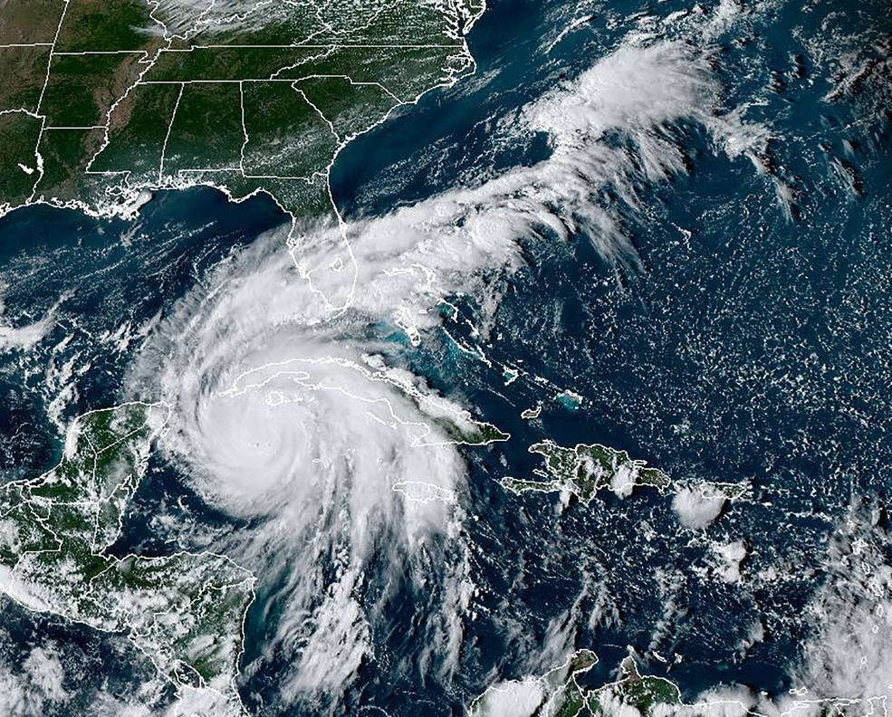
Hurricane Ian
The LRC (Lezak’s Recurring Cycle) can be used to calculate storms during hurricane season, based on indications of what has occurred during the cycling pattern since it evolved back in October. This falls hurricane season will have 3-4 landfall events, with a total of 7-9 hurricanes.
Florida will likely be hit again, with also a Gulf of Mexico and a Pacific storm, hitting somewhere between central to northern Mexico, including the possibility of San Diego, which rarely gets hurricanes.
Florida August 30-September 6th
This storm will come through Cuba, Puerto Rico or both hitting the eastern coast of Florida. It will then move north Northeast through the Carolinas and farther up the east coast exiting around Maine.
Sept 6-7th Louisiana (low possibility)
This storm is kind of either/or situation. If the above storm doesn’t hit Florida, it could take an alternate path, south of Florida, to Louisiana. Florida (above storm) is the most likely location. There is a possibility of this storm originating in the Gulf and moving East hitting the West Coast of Florida, but that is unlikely.
Yucatan Peninsula South to Honduras Sept 30 to October 3rd
Watch out Cancun travelers. This storm will originate in the Caribbean Sea and move west.
Pacific Storm Sept 30 to October 5th (Possibly 1 cycle earlier, August 12-17th)
This storm will originate of the South American west coast and move north northwest, likely west of Baja California, turning northeast around San Diego.
Thanks for reading, as always, if you have any questions, please email me at Mike@FutureSnow.CO
Video of the LRC Cycle Comparison 22-23
This took a little more work than usual, because I couldn’t find a good format to compare the three cycles. I finally settled on trimming each cycles width so that they could all fit on the screen.
The video moves at a slow pace, but even with the slow pace, it is hard to see everything on the screen, so use the slider to move at your own pace.
I am really proud of this video because first, it shows the fluctuation of the amplified pattern in each of the 3 cycles. Second, the storms are closely synchronized. With each frame advance, it is a quarter day. You can see how the storms in each cycle closely follow the same track with slightly different timing. Lastly, with the amplification, you can see how much the size and scope of the storms change. Especially the California storms. The amplification drops the storms to a more linear flow into the Sierra.
Open Resorts
California
Palisades
Utah
Snowbird, Solitude, Brighton
Colorado
Arapahoe Basin, Winter Park
Forecasted Areas
Pacific Northwest Cascade Mountains
Crystal Mountain, Mount Hood Meadows, Timberline, 49 Degrees North, Bachelor, Mt Baker,
Lake Tahoe Sierra Mountains
Heavenly, Palisades Tahoe, Kirkwood, Dodge Ridge, Donner Ski Ranch
Utah Wasatch Mountains
Alta, Park City, Deer Valley, Brighton, Snowbird, Brian Head
Colorado Rocky Mountains
Aspen, Aspen Highlands, Snowmass, Vail, Beaver Creek, Winter Park, Keystone, Arapahoe Basin, Breckenridge, Copper Mountain, Powderhorn, Ski Cooper, Telluride, Crested Butte, Silverton, Wolf Creek, Eldora, Loveland
–
