 Forecast Summary
Colorado
Not much has changed in the forecast since this last post. Today will be a carbon copy of yesterday with high winds along the ridgetops spilling into the valleys. Highs in the 50’s. The rain will begin late tonight, then change over to snow. Winds will be from the south southwest. I am expecting snow totals to be in the 4-8 range for most mountains above 8,000 ft.
This will be a great boost to snow making. Several ski areas are well underway, Arapahoe Basin, Breckenridge, Winter Park among others. Arapahoe Basin is scheduled to open Sunday.

Winter Park

Arapahoe Basin

U-Storm/Texas Hurricane Connection
 This storm is behaving like last year’s U-Storm, tracking from the PNW down to Utah, then turning north northeast and exiting through Minnesota.
We talked about the Texas hurricane location and timeline revised in the blogpost after Ida. Looking at the chart below, you can see the tropical storm below Baja Mexico, gather strength in the Pacific, crossing into Mexico and finally Texas, at about the time we predicted (October 20th). It is running a little late because it is taking a different path from the previous tropical indicators. Of course, snow is the focus of this blog but FutureHurricanes.com (coming soon) will by your go-to site for our fun side project.
This tropical storm does not look like it will strengthen once it reaches the Gulf of Mexico, but it is worth keeping an eye on. That means the remaining date of November 12th, will likely be New England, but it could also repeat in Florida or Texas.
Back to the U-Storm, looking at the chart below, at the 500 millibar level (about halfway up in the atmosphere), watch the energy dive deep forming a trough, it begins to wobble and eventually gets cut-off from the flow (not shown). That’s pretty cool, it is stronger than last year’s version which should produce deep powder and a boost to snowpack. We will monitor this system to gage its strength the next time thru. Either way though, it should be a winner each cycle, but which one will be the best? Stay tuned.

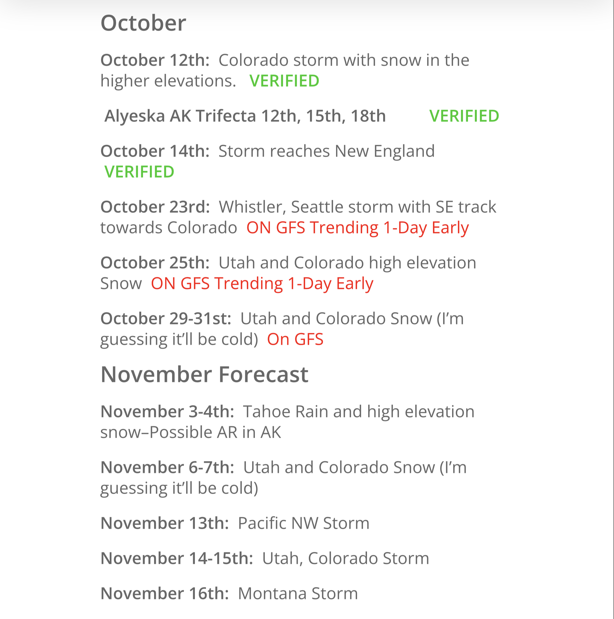
Season on the Horizon
I am really excited about this upcoming season. The pattern is verifying. Below is the “rough draft” and things are lining up really well.
Thank you for reading the blog, we have some exciting things that I will be introducing soon. As always if you have any questions, please email me to: mike@futuresnow.co
We have received so many emails, it’s exciting to me that there are so many questions. We will answer them all, please give us a little time and we will respond. We will begin charging for subscriptions sometime in December, for a very reasonable price.
