Daily Snow Stakes


Pattern Discussion
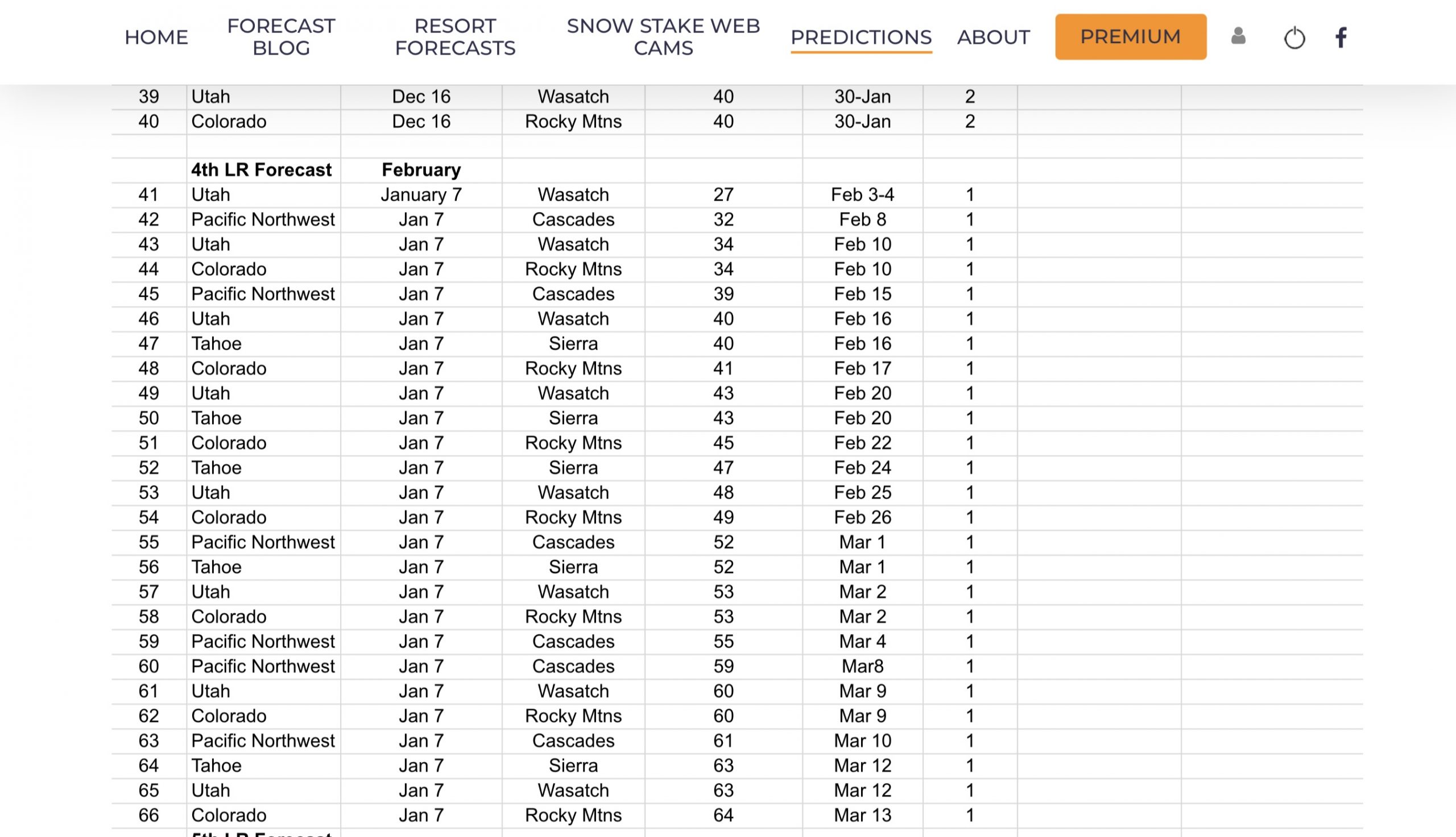
We just had our first storm verify from the 4th set of Long-Range Forecast Predictions. It is hard to wait, this time 27 days, for the storm to verify. I always breathe a sigh of relief when first, I see it on the GFS, and then when it verifies.
Storm 42 is making its way through the Cascades today and tonight, before going through the Wasatch range, then the Rockies around midday on Wednesday.

We have been watching the Madden Jullian Oscillation (MJO) as we believe we have a correlation between enhanced, or amplified storms and precipitation, with the MJO being in phases 6,7 and 8. The MJO is looking to enter those phases around the 14th. We are already seeing larger storms on the horizon, beginning with storm 45 on the 15th.
We know that during last year’s cycle 2, that the MJO played a role in an amplified pattern, for about half of the cycle, before falling out of phase. This year, the MJO has been in a favorable phase in parts of each of the last two cycles. Which is seemingly the key for Lake Tahoe.
When the MJO is in a good spot, we have good storms for the Lake. When the MJO is not in a good spot, the storms that should be there miss–usually. This could be huge for accurately predicting storms for Tahoe, because we do have a pretty good sense of forecasting the MJO at least 10 days in advance.
Surface Chart
 All Snow Chart

Forecast
Heavy snow today with Winter Storm Warnings in the Pacific Northwest through tomorrow. Temperatures begin the day around the mid 30’s and will be dropping throughout the day. Expect strong winds, especially in the southern Cascades, between 20-30 with 45-50 mph gusts, take off about 10 mph for the northern Cascade resorts. Most resorts will receive between 1-3 feet.
Snowfall graphic below, watch out for rain/snow mix at Snoqualmie, it should be all snow later in the day, as the colder temperatures slide in.

Utah
This system reaches Utah resorts during the day tomorrow, likely around 11-12 pm. This is nott looking super strong for this year’s standards, but a nice refill of new snow, around 3-5 likely. I will keep an eye out for changes to the model numbers.
Colorado
The storm reaches Colorado tomorrow night. I will post expected totals tomorrow.
Meteorologist Gary Lezak
Gary posted an excellent breakdown of the upcoming storms from Sundays blog, if you didn’t get a chance to look at it, make sure you check it out-–Garys Post.


Thank you for reading the blog, as always, if you have any questions, or need personalized info for trip forecasts, please email me at Mike@FutureSnow.co
Long-Range Forecast Predictions thru March
 Forecasted Areas
Pacific Northwest Cascade Mountains
Crystal Mountain, Mount Hood Meadows, Timberline, 49 Degrees North, Bachelor, Mt Baker,
Lake Tahoe Sierra Mountains
Heavenly, Palisades Tahoe, Kirkwood, Dodge Ridge, Donner Ski Ranch
Utah Wasatch Mountains
Alta, Park City, Deer Valley, Brighton, Snowbird, Brian Head
Colorado Rocky Mountains
Aspen, Aspen Highlands, Snowmass, Vail, Beaver Creek, Winter Park, Keystone, Arapahoe Basin, Breckenridge, Copper Mountain, Powderhorn, Ski Cooper, Telluride, Crested Butte, Silverton, Wolf Creek, Eldora, Loveland
–
