Posted March 23, 6:49 am MT 5:49 am PT
Alta is at 718–just 30 inches away from the all-time record. They could break the record as early as Friday or Saturday.
MSLP Surface Chart
 High Resolution HRRR Model Click to Animate
Pattern Discussion
The pattern is cycling through at its regular strength, which is stronger than La Nina years, for comparison. The MJO in heading towards neutral position and is currently in the Indian ocean. The last time through, the MJO went directly to the western Pacific, when it reformed. It looks to do the same again, which could put us in the enhanced pattern in early April.
We got a late start to this year’s pattern. It seems spring will be late in starting as well. That is great because we have records to break. Looking at the AO (Artic Oscillation) and the NAO (North Atlantic Oscillation) charts, the AO is moving towards neutral, the NAO is diving negative.
You may think, what does the North Atlantic have to do with the west? It is all connected, when the NAO is negative, the westerly winds typically die down and we have colder and dryer weather in Europe. The two oscillations influence each other, meaning the negative NAO can make the AO turn negative. Negative AO equals a better chance of cold air, which can extend winter even farther.
Forecast Discussion
Heavy snow today in the southern Cascade ranges, as 2-3 feet will fall for Mt Bachelor, Hoodoo, Mt Hood Meadows and Timberline, by tomorrow morning. The heavy snow will continue through Friday night and likely into Saturday. Snowfall in the Northern Cascades will be on the lighter side, but still good, between 1-2 feet, with the heaviest snow falling Friday and Saturday.
Lake Tahoe will see snow showers this morning until around noon, then clouds the rest of the day with moderate winds. Storm 3 will dive down into the Sierra tonight bringing modest totals for a good refresh for first chair tomorrow.
For Utah, the snow show continues everyday through Sunday. Today’s snowfall will be relatively light today, with a break in the action in the afternoon. The first wave from storm 3 arrives tonight, with heavy snow before the lifts open tomorrow. Tomorrow is a “ride the storm” day as there will be heavy snow throughout the day with totals in the 1-2 feet range. Woohoo!
Alta is at 718–just 30 inches away from the all-time record. They could break the record as early as Friday or Saturday.
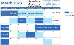
For Colorado, we have a break in the action until Friday night, when storm 3 arrives.
Forecast
Utah
Light snow this morning with light winds between 10-15 mph, Temperatures will top out around 20 this afternoon, after a morning low of 5 degrees.
Tonight
Heavy snow tonight with deep totals possible for first chair tomorrow.
Tomorrow
Heavy snow throughout the day with moderate winds between 20-25 mph with gust in the 30’s.
Colorado
Scattered snow showers today with not much precipitation expected. Winds will be light between 5-10 mph with high temperatures in the low 30’s. Tomorrow will be more of the same, scattered snow showers with low totals and high temperatures in the low 30’s.
Friday Night
Storm 3 arrives and will bring good totals for first chair Saturday. I will have totals tomorrow.
Lake Tahoe
Scattered snow showers this morning, adding 2-4 or 3-5 by 10 o’clock this morning. Temperatures will be in the mid 20’s with moderate winds 15-20 mph with base level gusts around 30 mph.
Tonight
Decent snow totals overnight between 5-10 inches for Kirkwood, Donner Summit, Palisades and Sugar Bowl. Cold temperatures will make the snow nice and light for first chair tomorrow.
Friday
Bluebird skies and low temps, near 30 at 6000 feet. It will be a gorgeous day with light winds from the west. Don’t forget sunscreen.
Tahoe Calendar
Below is the Lake Tahoe Calendar we published back on February 2nd. I have gone back and took a look at the calendars to see how we have done. The green squares are on the Long-Range Forecast prediction chart. Yellow squares are storms that have hit at least one cycle. Red Circles and X’s are misses and the Blue brackets are storms that have hit at within one day.
I am really happy with this calendar. We have tried to figure out the Lake, as it is on a different type of cycle, due to its location away from the general pattern jet stream. We are improving, the patent pending model has made forecasting Lake Tahoe easier.
Long-Range Forecast Predictions are out thru April
Forecasted Areas
Pacific Northwest Cascade Mountains
Crystal Mountain, Mount Hood Meadows, Timberline, 49 Degrees North, Bachelor, Mt Baker,
Lake Tahoe Sierra Mountains
Heavenly, Palisades Tahoe, Kirkwood, Dodge Ridge, Donner Ski Ranch
Utah Wasatch Mountains
Alta, Park City, Deer Valley, Brighton, Snowbird, Brian Head
Colorado Rocky Mountains
Aspen, Aspen Highlands, Snowmass, Vail, Beaver Creek, Winter Park, Keystone, Arapahoe Basin, Breckenridge, Copper Mountain, Powderhorn, Ski Cooper, Telluride, Crested Butte, Silverton, Wolf Creek, Eldora, Loveland


