Daily Snow Stake


Surface Chart
I’m letting the surface chart run out to 162 hours, to show the next couple of systems coming through. There is a cut-off low that swings through Lake Tahoe and takes a southern track, hitting Taos, and southern Colorado. The big storm follows, this is the Presidents Week storm and it is looking to be amplified.

All Snow Chart

Pattern Discussion
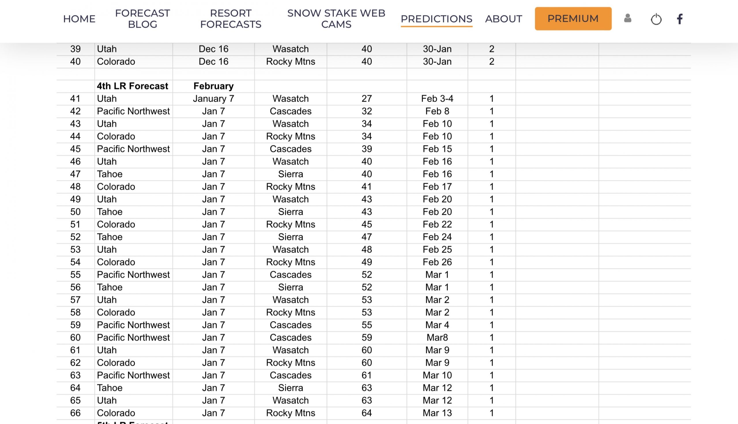
We have been keeping an eye on the teleconnections for the mid-February storm systems, that we were talking about since Christmas. Check out the LRC Model forecast on December 25th.

This model run goes all the way through March, So we will have to wait to see how accurate the temperature and storm predictions are. The model is calling for above average temperatures in the Cascades and an arctic blast for Nevada and Utah, around February 18th.

Let’s look at the storm breakdown. We know that using the LRC we will know when the storm systems will come through. What is hard to tell is how strong the storm systems will be when they come. With the LRC model, we have a better idea of the strength of those storms.
We had a strong storm come through at the end of January, that dumped double digit totals in Utah and Colorado. 3-day totals at Alta 23, Snowbird 23, Park City 15 and Brighton 33.
In Colorado, Beaver Creek 23, Vail 24, Steamboat 31 and Crested Butte 21.


Forecast
The storm moves out of Colorado this morning; we might squeeze a couple more inches out of the system on the way out. The next system is the cut off low that will move through Lake Tahoe tomorrow night. The models are not in agreement as to where the snow will fall. Remember the expression, cut-off low weatherman’s woe. I will wait until tomorrow to give the totals, but for now, it will be in the 4-10 range for wherever the hotspot is.
Just a brief history of this storm, in cycle 1 Kirkwood received 12, from this storm. The storm missed in cycle 2, so this goes back to what we talked about teleconnections wise. When the pattern is amplified, and the steering connections, like the artic oscillation align, the storms hit the lake. We are heading in the right direction for the Madden Jullian Oscillation. That is where the amplification we discussed above, comes into play. It looks to be right on time with the LRC model forecast. I’ll leave you with the MJO chart–once it enters phase 6, were golden. At the beginning of the green line, in phase 4 was yesterday.

Thank you for reading the blog, as always, if you have any questions, or need personalized info for trip forecasts, please email me at Mike@FutureSnow.co
Long-Range Forecast Predictions thru March
 Forecasted Areas
Pacific Northwest Cascade Mountains
Crystal Mountain, Mount Hood Meadows, Timberline, 49 Degrees North, Bachelor, Mt Baker,
Lake Tahoe Sierra Mountains
Heavenly, Palisades Tahoe, Kirkwood, Dodge Ridge, Donner Ski Ranch
Utah Wasatch Mountains
Alta, Park City, Deer Valley, Brighton, Snowbird, Brian Head
Colorado Rocky Mountains
Aspen, Aspen Highlands, Snowmass, Vail, Beaver Creek, Winter Park, Keystone, Arapahoe Basin, Breckenridge, Copper Mountain, Powderhorn, Ski Cooper, Telluride, Crested Butte, Silverton, Wolf Creek, Eldora, Loveland
–
